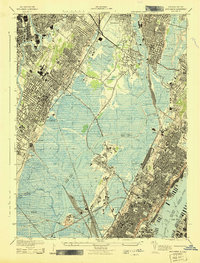
1943 Map of Weehawken
USGS Topo · Published 1943About this map
Jersey City and the surrounding urban industrial corridor of northern New Jersey are captured here during World War II, revealing a landscape defined by expansive rail yards and maritime infrastructure. The extensive Secaucus Yards and the sprawling marshlands surrounding the Hackensack River dominate the central portion of the sheet, while the heights of the Palisades support dense residential development. The presence of Bendix Airport and various industrial facilities reflects the region's importance to the war effort.
Find a feature on this map
66 named features on this map. Tap any name to fly to it.
Don’t see what you’re looking for? This feature index may not catch every label — zoom into the map to look around manually.
Map Details
Editions of this 1943 Weehawken Map
This is the sole edition of this map. No revisions or reprints were ever made.
Other maps of this area

1888 · Paterson
USGS Topo · 1:62,500

1889 · Brooklyn
USGS Topo · 1:62,500

1891 · Brooklyn
USGS Topo · 1:62,500

1891 · Harlem
USGS Topo · 1:62,500

1892 · Paterson
USGS Topo · 1:62,500

1897 · Harlem
USGS Topo · 1:62,500

1897 · Brooklyn
USGS Topo · 1:62,500

1898 · Harlem
USGS Topo · 1:62,500

1898 · Staten Island
USGS Topo · 1:62,500

1898 · Brooklyn
USGS Topo · 1:62,500