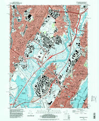
1995 Map of Weehawken
USGS Topo · Published 1998About this map
The dense urban industrial corridor of Bergen and Hudson Counties is defined by a complex network of marshes, rail yards, and riverfronts. In the mid-1990s, the Hackensack River and Passaic River frame a landscape of heavy transport infrastructure, including the massive rail operations at Croxton Yards and the sprawling Teterboro Airport. High-density residential zones in Union City, West New York, and Passaic contrast sharply with the preserved wetlands of the Saw Mill Creek State Wildlife Management Area and the Walden Swamp. The map provides significant detail for genealogists and local historians, featuring numerous educational and religious landmarks such as Fairleigh Dickinson University and St Marys High Sch, alongside a concentration of burial grounds including Flower Hill Cem and the Palisades Cem situated along the heights overlooking the Hudson River.
Find a feature on this map
120 named features on this map. Tap any name to fly to it.
Don’t see what you’re looking for? This feature index may not catch every label — zoom into the map to look around manually.
Map Details
Editions of this 1995 Weehawken Map
This is the sole edition of this map. No revisions or reprints were ever made.
Other maps of this area

1888 · Paterson
USGS Topo · 1:62,500

1889 · Brooklyn
USGS Topo · 1:62,500

1891 · Brooklyn
USGS Topo · 1:62,500

1891 · Harlem
USGS Topo · 1:62,500

1892 · Paterson
USGS Topo · 1:62,500

1897 · Harlem
USGS Topo · 1:62,500

1897 · Brooklyn
USGS Topo · 1:62,500

1898 · Harlem
USGS Topo · 1:62,500

1898 · Staten Island
USGS Topo · 1:62,500

1898 · Brooklyn
USGS Topo · 1:62,500