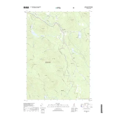
2018 Map of West Milan
USGS Topo · Published 2018About this map
The Upper Ammonoosuc River winds through the heart of this North Country landscape, carving a valley that contains the primary settlements of West Milan and Crystal. This 2018 survey reveals a terrain defined by significant elevation changes, with the massive White Mountain National Forest occupying the southern half of the quadrangle. High-altitude landmarks such as Rogers Ledge, North Peak, and Greens Ledge tower over the drainage basins of Phillips Brook and Pond Brook.
Find a feature on this map
75 named features on this map. Tap any name to fly to it.
Don’t see what you’re looking for? This feature index may not catch every label — zoom into the map to look around manually.
Map Details
Editions of this 2018 West Milan Map
This is the sole edition of this map. No revisions or reprints were ever made.
Other maps of this area

1893 · Mt. Washington
USGS Topo · 1:62,500

1893 · Gorham
USGS Topo · 1:62,500

1896 · Mt. Washington
USGS Topo · 1:62,500

1896 · Gorham
USGS Topo · 1:62,500

1930 · Milan
USGS Topo · 1:62,500

1930 · Percy
USGS Topo · 1:62,500

1933 · Milan
USGS Topo · 1:62,500

1934 · Percy
USGS Topo · 1:62,500

1934 · Milan
USGS Topo · 1:62,500

1935 · Mt. Washington
USGS Topo · 1:62,500