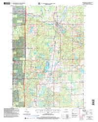
2005 Map of Westboro
USGS Topo · Published 2006About this map
Glacial landforms and dense woodlands define this section of the Chequamegon National Forest in northern Taylor County. The landscape is dotted with kettle ponds and glacial lakes, including Kettle Lake, Skinner Lake, and the larger Wellington Lake to the east. The primary settlements of Westboro and Chelsea serve as the historical hubs for this rural timber and dairy region, connected by a north-south corridor that follows the winding course of Black Creek.
Find a feature on this map
36 named features on this map. Tap any name to fly to it.
Don’t see what you’re looking for? This feature index may not catch every label — zoom into the map to look around manually.
Map Details
Editions of this 2005 Westboro Map
This is the sole edition of this map. No revisions or reprints were ever made.
Other maps of this area

1902 · Marathon
USGS Topo · 1:125,000

1944 · Ogema
USGS Topo · 1:48,000

1945 · Rib Lake
USGS Topo · 1:48,000

1947 · Rib Lake
USGS Topo · 1:48,000

1947 · Ogema
USGS Topo · 1:48,000

1949 · Ogema
USGS Topo · 1:48,000

1949 · Rib Lake
USGS Topo · 1:48,000

1951 · Athens
USGS Topo · 1:48,000

1951 · Medford
USGS Topo · 1:48,000

1953 · Rice Lake
USGS Topo · 1:250,000