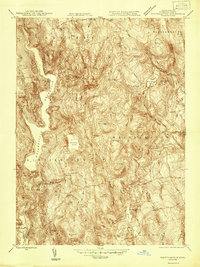
1946 Map of Westhampton
USGS Topo · Published 1946About this map
The Knightville Reservoir dominates the western landscape of this Hampshire County survey, illustrating the mid-century engineering of the Westfield River basin. In the years following World War II, the area maintained its traditional rural character, defined by scattered hamlets like Westhampton and Norwich. Local industry is represented by the Bisbee Mill near the northern boundary, while the surrounding hills are dotted with family-named landmarks such as Bascam Hill and Horse Hill. Genealogists will find significant value in the documentation of local burial grounds, including Torrey Cem, Bofat Cem, and Damon Cem. The complex drainage patterns of Dead Branch and the Manhan River reveal a landscape deeply tied to its water sources, from the isolated Norwich Pond to the developed shores of Pine Island Lake.
Find a feature on this map
53 named features on this map. Tap any name to fly to it.
Don’t see what you’re looking for? This feature index may not catch every label — zoom into the map to look around manually.
Map Details
Editions of this 1946 Westhampton Map
This is the sole edition of this map. No revisions or reprints were ever made.
Other maps of this area

1885 · Northampton
USGS Topo · 1:62,500

1886 · Springfield
USGS Topo · 1:62,500

1886 · Chesterfield
USGS Topo · 1:62,500

1886 · Northampton
USGS Topo · 1:62,500

1887 · Granville
USGS Topo · 1:62,500

1888 · Chesterfield
USGS Topo · 1:62,500

1889 · Springfield
USGS Topo · 1:62,500

1889 · Granville
USGS Topo · 1:62,500

1891 · Northampton
USGS Topo · 1:62,500

1893 · Northampton
USGS Topo · 1:62,500