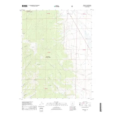
2019 Map of Whale Hill
USGS Topo · Published 2019About this map
The boundary between the Rio Grande National Forest and San Isabel National Forest bisects this high-elevation landscape in Saguache County. The terrain is defined by a series of prominent summits including Hayden Peak, Mt Manitou, and the namesake Whale Hill, which rise above deep drainage systems such as Rawley Gulch and Chloride Gulch. The small settlement of Alder sits in the northern reaches of the quadrangle along the valley of Alder Creek, serving as a waypoint near where San Luis Creek flows toward the basin. The map reveals a complex network of canyons and ridges, including Center Ridge and Burnt Mtn, carved by seasonal waterways like Kelly Creek and Cottonwood Creek. This area illustrates the transition from the high peaks of the Sangre de Cristo and Sawatch ranges down toward the San Luis Valley floor, with old forest roads such as Co RD uu52 providing access to the rugged interior.
Find a feature on this map
39 named features on this map. Tap any name to fly to it.
Don’t see what you’re looking for? This feature index may not catch every label — zoom into the map to look around manually.
Map Details
Editions of this 2019 Whale Hill Map
This is the sole edition of this map. No revisions or reprints were ever made.
Other maps of this area

1954 · Pueblo
USGS Topo · 1:250,000

1956 · Montrose
USGS Topo · 1:250,000

1957 · Pueblo
USGS Topo · 1:250,000

1958 · Pueblo
USGS Topo · 1:250,000

1959 · Montrose
USGS Topo · 1:250,000

1959 · Bonanza
USGS Topo · 1:62,500

1959 · Howard
USGS Topo · 1:62,500

1960 · Montrose
USGS Topo · 1:250,000

1962 · Pueblo
USGS Topo · 1:250,000

1966 · Pueblo
USGS Topo · 1:250,000