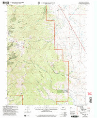
2001 Map of Whale Hill
USGS Topo · Published 2005About this map
Villa Grove Mine and a high concentration of mineral claims dominate this Saguache County landscape, reflecting a long history of resource extraction on the eastern slopes of the San Luis Valley. The map documents an intricate network of shafts and prospects, including the Colorado Belle Mine, Legal Tender Mine, and Oregon Mine, scattered across high-elevation peaks like Elkhorn Peak and Hayden Peak. The transition from the flatlands near Alder to the high ridges of the Rio Grande National Forest is marked by a landscape carved by canyons such as Michigan Gulch and Elkhorn Gulch. Transportation routes here are specialized, featuring the Stock Driveway for livestock movement and the Express Trail, alongside several unnamed 4WD roads that navigate the complex terrain around Round Mountain.
Find a feature on this map
53 named features on this map. Tap any name to fly to it.
Don’t see what you’re looking for? This feature index may not catch every label — zoom into the map to look around manually.
Map Details
Editions of this 2001 Whale Hill Map
This is the sole edition of this map. No revisions or reprints were ever made.
Other maps of this area

1954 · Pueblo
USGS Topo · 1:250,000

1956 · Montrose
USGS Topo · 1:250,000

1957 · Pueblo
USGS Topo · 1:250,000

1958 · Pueblo
USGS Topo · 1:250,000

1959 · Montrose
USGS Topo · 1:250,000

1959 · Bonanza
USGS Topo · 1:62,500

1959 · Howard
USGS Topo · 1:62,500

1960 · Montrose
USGS Topo · 1:250,000

1962 · Pueblo
USGS Topo · 1:250,000

1966 · Pueblo
USGS Topo · 1:250,000