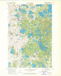
1969 Map of White Earth
USGS Topo · Published 1971About this map
White Earth serves as the focal point of this Becker County survey, surrounded by an intricate landscape of kettle lakes and protected wetlands. The community’s cultural geography is defined by landmarks like St Benedicts Mission, St Columba Ch, and Calvary Cem, reflecting its long-standing social foundations. This 1960s snapshot captures the region before extensive modern development, highlighting a heavy reliance on the natural environment through features like the Wabaunaguat Boy Scout Camp and various conservation zones. A massive complex of interconnected water bodies, including Big Sugar Bush Lake and White Earth Lake, dominates the eastern and southern portions of the quadrangle. Significant acreage is dedicated to preservation, notably the Teiken-Dalve State Wildlife Management Area and various National Wildlife Management Area tracts, which suggest a transition toward formal wilderness stewardship in this lake-rich territory.
Find a feature on this map
55 named features on this map. Tap any name to fly to it.
Don’t see what you’re looking for? This feature index may not catch every label — zoom into the map to look around manually.
Map Details
Editions of this 1969 White Earth Map
This is the sole edition of this map. No revisions or reprints were ever made.
Other maps of this area

1953 · Brainerd
USGS Topo · 1:250,000

1954 · Bemidji
USGS Topo · 1:250,000

1957 · Brainerd
USGS Topo · 1:250,000

1957 · Bemidji
USGS Topo · 1:250,000

1958 · Bemidji
USGS Topo · 1:250,000

1958 · Brainerd
USGS Topo · 1:250,000

1959 · Flat Lake
USGS Topo · 1:24,000

1959 · Richwood
USGS Topo · 1:24,000
1959 · Callaway
USGS Topo · 1:24,000

1965 · Brainerd
USGS Topo · 1:250,000