
Loading...
Loading map...2023 Map of Whitney Point
USGS Topo · Published 2023About this map
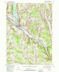
Whitney Point serves as the focal point of this northern Broome County landscape, situated at the significant confluence where the Otselic River joins the Tioughnioga River. The area's history is deeply etched into its hills and valleys, visible through a dense network of burial grounds like Riverside Cem and Saint Patrick Cem near the village center, and more isolated sites such as Page Brook Cem to the north.
Find a feature on this map
77 named features on this map. Tap any name to fly to it.
Don’t see what you’re looking for? This feature index may not catch every label — zoom into the map to look around manually.
Map Details
Date Portrayed2023
Date Published2023
PublisherU.S. Geological Survey
Map TypeTopographic
Scale1:24000
Physical Dimensions24 x 29 inches
Editions of this 2023 Whitney Point Map
This is the sole edition of this map. No revisions or reprints were ever made.
Historical Maps of Nanticoke Through Time
3 maps found
Featured Locations
Source Details
SourceU.S. Geological Survey
CopyrightPublic Domain