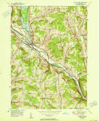
1951 Map of Whitney Point
USGS Topo · Published 1951About this map
The Whitney Point Flood Control Dam stands as a massive mid-century engineering feat, regulating the Otselic River just before its confluence with the Tioughnioga River. This 1951 record shows the landscape shortly after the dam's construction, featuring a prominent Spillway 1010 and a large reservoir that altered the local topography. Nearby, the village of Whitney Point serves as a central hub, where the Fairgrounds and a Gaging Sta are marked along the riverbanks.
Find a feature on this map
45 named features on this map. Tap any name to fly to it.
Don’t see what you’re looking for? This feature index may not catch every label — zoom into the map to look around manually.
Map Details
Editions of this 1951 Whitney Point Map
This is the sole edition of this map. No revisions or reprints were ever made.
Other maps of this area

1901 · Apalachin
USGS Topo · 1:62,500

1903 · Harford
USGS Topo · 1:62,500

1904 · Binghamton
USGS Topo · 1:62,500

1904 · Greene
USGS Topo · 1:62,500

1904 · Apalachin
USGS Topo · 1:62,500

1906 · Catatonk
USGS Topo · 1:125,000

1934 · Castle Creek
USGS Topo · 1:24,000

1935 · Chenango Forks
USGS Topo · 1:24,000

1942 · Castle Creek
USGS Topo · 1:31,680

1942 · Chenango Forks
USGS Topo · 1:31,680