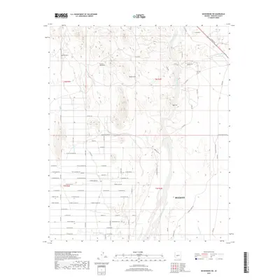
2018 Map of Wickenburg SW
USGS Topo · Published 2018About this map
The Hassayampa River corridor dominates this desert landscape, cutting a wide sandy channel through the alluvial plains of Maricopa County. This 2018 survey captures a region of transitioning land use, where the northern outskirts of Buckeye meet the southern slopes of the Vulture Mountains. The terrain is defined by dry drainage systems such as Little San Domingo Wash, Daggs Wash, and Wagner Wash, which reveal the complex hydrology of the Sonoran Desert. Geologic landmarks such as Vulture Arch, Natural Arch, and the prominence of Red Cliff provide distinctive navigation points across the arid expanse. The map shows a growing network of residential roads like W Villa Cassandra Way and W Paint Wagon Trl pushing into the desert, while traditional ranching or utility features like Buckhorn Tank and the Ranta Strip persist on the margins of the expanding settlement.
Find a feature on this map
67 named features on this map. Tap any name to fly to it.
Don’t see what you’re looking for? This feature index may not catch every label — zoom into the map to look around manually.
Map Details
Editions of this 2018 Wickenburg SW Map
This is the sole edition of this map. No revisions or reprints were ever made.
Other maps of this area

1954 · Phoenix
USGS Topo · 1:250,000

1957 · Phoenix
USGS Topo · 1:250,000

1957 · White Tank Mts. NE
USGS Topo · 1:24,000

1957 · White Tank Mts.
USGS Topo · 1:62,500

1958 · Phoenix
USGS Topo · 1:250,000

1960 · Phoenix
USGS Topo · 1:250,000

1961 · Vulture Mountains
USGS Topo · 1:62,500

1962 · Belmont Mts
USGS Topo · 1:62,500
1964 · Wickenburg
USGS Topo · 1:24,000
1964 · Red Picacho
USGS Topo · 1:24,000