1974 Map of Wildomar
USGS Topo · Published 1977About this map
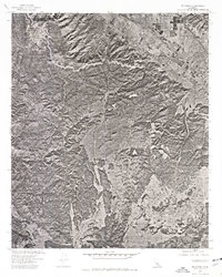
Wildomar is captured in this orthophotograph as a growing grid of agricultural parcels and developing residential blocks on the edge of the southern California backcountry. This 1974 aerial imagery, produced in cooperation with the U.S. Soil Conservation Service, reveals a landscape defined by the sharp transition between valley development and the high ridges of the Santa Ana Mountains. The map provides a unique visual record of land use before modern urbanization fully reshaped the region, showing the exact footprint of orchards and fields that once dominated the area. Within the steep terrain to the west and south, the deep drainages of Los Alamos Canyon and Slaughterhouse Canyon cut through the hills, illustrating the natural obstacles that influenced the early surveying and settlement patterns of this Riverside County locale.
Find a feature on this map
4 named features on this map. Tap any name to fly to it.
Don’t see what you’re looking for? This feature index may not catch every label — zoom into the map to look around manually.
Map Details
Editions of this 1974 Wildomar Map
This is the sole edition of this map. No revisions or reprints were ever made.
Other maps of this area

1901 · Southern California Sheet No. 1
USGS Topo · 1:250,000

1901 · Elsinore
USGS Topo · 1:125,000

1901 · San Luis Rey
USGS Topo · 1:125,000

1904 · Southern California Sheet No. 2
USGS Topo · 1:250,000

1904 · Southern California Sheet No. 1
USGS Topo · 1:250,000

1941 · Margarita Peak
USGS Topo · 1:62,500

1942 · Lake Elsinore
USGS Topo · 1:62,500

1942 · Margarita Peak
USGS Topo · 1:62,500

1942 · Temecula
USGS Topo · 1:62,500

1942 · Murrieta
USGS Topo · 1:62,500