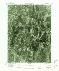
1975 Map of Williamsburg
USGS Topo · Published 1981About this map
Williamsburg and Haydenville occupy the southern reaches of this 1975 aerial orthophotograph, showing the village layouts along the banks of the Mill River. The imagery reveals the contrast between the concentrated mill-town settlements and the heavily forested uplands of Franklin County. In the central part of the quadrangle, the Mountain Street Reservoir sits amidst the wooded terrain, providing a significant landmark between the larger towns and the smaller communities of West Whately and Whately to the east. Traces of the mid-1970s landscape are visible in the patterns of clearing and woodlots near Searsville, reflecting the rural character of the region before late-twentieth-century development. This orthophoto provides a precise record of the physical geography and building footprints during a transitional period for Massachusetts hill towns.
Find a feature on this map
7 named features on this map. Tap any name to fly to it.
Don’t see what you’re looking for? This feature index may not catch every label — zoom into the map to look around manually.
Map Details
Editions of this 1975 Williamsburg Map
This is the sole edition of this map. No revisions or reprints were ever made.
Other maps of this area

1885 · Northampton
USGS Topo · 1:62,500

1886 · Hawley
USGS Topo · 1:62,500

1886 · Chesterfield
USGS Topo · 1:62,500

1886 · Northampton
USGS Topo · 1:62,500

1888 · Chesterfield
USGS Topo · 1:62,500

1890 · Hawley
USGS Topo · 1:62,500

1890 · Greenfield
USGS Topo · 1:62,500

1891 · Northampton
USGS Topo · 1:62,500

1893 · Northampton
USGS Topo · 1:62,500

1893 · Chesterfield
USGS Topo · 1:62,500