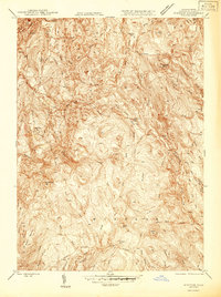
1946 Map of Windsor
USGS Topo · Published 1946About this map
The Berkshire hills of Western Massachusetts are defined by a network of steep elevations and rushing brooks in this mid-1940s survey. Significant terrain features like Borden Mtn and Weston Mountain dominate the landscape, while the Appalachian Trail winds through the western ridges near Adams. Small mountain settlements including Savoy Center, Savoy, and Windsor serve as the primary hubs of human activity, connected by local routes such as Savoy Hollow Road.
Find a feature on this map
38 named features on this map. Tap any name to fly to it.
Don’t see what you’re looking for? This feature index may not catch every label — zoom into the map to look around manually.
Map Details
Editions of this 1946 Windsor Map
This is the sole edition of this map. No revisions or reprints were ever made.
Other maps of this area

1886 · Greylock
USGS Topo · 1:62,500

1886 · Hawley
USGS Topo · 1:62,500

1886 · Chesterfield
USGS Topo · 1:62,500

1886 · Becket
USGS Topo · 1:62,500

1888 · Becket
USGS Topo · 1:62,500

1888 · Chesterfield
USGS Topo · 1:62,500

1890 · Hawley
USGS Topo · 1:62,500

1891 · Greylock
USGS Topo · 1:62,500

1893 · Chesterfield
USGS Topo · 1:62,500

1893 · Becket
USGS Topo · 1:62,500