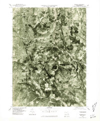
1975 Map of Windsor
USGS Topo · Published 1981About this map
Windsor and Savoy sit at the center of this 1975 aerial perspective, showing the landscape of the Berkshire highlands as it appeared in the mid-1970s. The orthophoto format reveals the dense forest cover and occasional clearings that define the region, including the prominent rise of Borden Mountain. In the northwestern corner, a portion of Adams is visible along the banks of the Hoosic River, contrasting with the more rural character of Bowens Corners. The drainage of the Westfield River cuts through the southeastern portion of the map, illustrating the watershed divide that characterizes this part of Massachusetts. This survey provides researchers with a clear view of the road networks and land use patterns before late-twentieth-century developments altered the local character.
Find a feature on this map
7 named features on this map. Tap any name to fly to it.
Don’t see what you’re looking for? This feature index may not catch every label — zoom into the map to look around manually.
Map Details
Editions of this 1975 Windsor Map
This is the sole edition of this map. No revisions or reprints were ever made.
Other maps of this area

1886 · Greylock
USGS Topo · 1:62,500

1886 · Hawley
USGS Topo · 1:62,500

1886 · Chesterfield
USGS Topo · 1:62,500

1886 · Becket
USGS Topo · 1:62,500

1888 · Becket
USGS Topo · 1:62,500

1888 · Chesterfield
USGS Topo · 1:62,500

1890 · Hawley
USGS Topo · 1:62,500

1891 · Greylock
USGS Topo · 1:62,500

1893 · Chesterfield
USGS Topo · 1:62,500

1893 · Becket
USGS Topo · 1:62,500