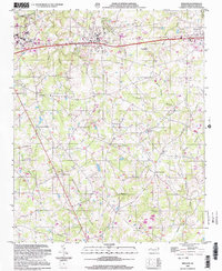
2002 Map of Wingate
USGS Topo · Published 2003About this map
Wingate College sits at the heart of this Piedmont landscape, anchored by the town of Wingate and extending eastward toward Marshville. The area is defined by a dense network of minor waterways including Ray Fork, Beaverdam Creek, and Lanes Creek, which create a rolling agricultural and residential topography. This map reflects a transition toward suburban development while maintaining deep roots in its rural past, evidenced by the numerous country churches and crossroads settlements that dot the county roads.
Find a feature on this map
40 named features on this map. Tap any name to fly to it.
Don’t see what you’re looking for? This feature index may not catch every label — zoom into the map to look around manually.
Map Details
Editions of this 2002 Wingate Map
This is the sole edition of this map. No revisions or reprints were ever made.
Other maps of this area

1941 · Charlotte
USGS Topo · 1:125,000

1941 · Spartanburg
USGS Topo · 1:250,000

1942 · Charlotte
USGS Topo · 1:125,000

1953 · Spartanburg
USGS Topo · 1:250,000

1953 · Charlotte
USGS Topo · 1:250,000

1954 · Charlotte
USGS Topo · 1:250,000

1960 · Charlotte
USGS Topo · 1:250,000

1960 · Spartanburg
USGS Topo · 1:250,000

1962 · Charlotte
USGS Topo · 1:250,000

1963 · Spartanburg
USGS Topo · 1:250,000