
Loading...
Loading map...2021 Map of Wittmann
USGS Topo · Published 2021About this map
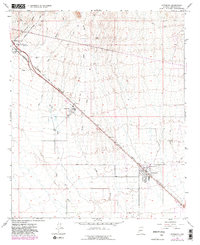
The settlement of Wittmann anchors this 2021 survey of the Maricopa County desert, where a diagonal corridor of infrastructure cuts through the alluvial landscape. Parallel to N Grand Ave, the map reveals a series of aviation and industrial footprints, including Castle Well Airport, Roesner Ranch Airport, and Thunder Ridge Airpark. These small strips, alongside the expansive Chrysler Corp Proving grounds, illustrate the region's long-standing utility for testing and private flight.
Find a feature on this map
41 named features on this map. Tap any name to fly to it.
Don’t see what you’re looking for? This feature index may not catch every label — zoom into the map to look around manually.
Map Details
Date Portrayed2021
Date Published2021
PublisherU.S. Geological Survey
Map TypeTopographic
Scale1:24000
Physical Dimensions24 x 29 inches
Editions of this 2021 Wittmann Map
This is the sole edition of this map. No revisions or reprints were ever made.
Historical Maps of Morristown Through Time
Featured Locations
Source Details
SourceU.S. Geological Survey
CopyrightPublic Domain