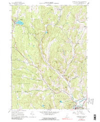
1976 Map of Woodstock North
USGS Topo · Published 1988About this map
The village of Woodstock sits at the southern edge of this mid-1970s survey, where the Ottauquechee River meets the hills of central Vermont. This landscape is defined by its deep valley hollows and the network of brooks that feed them, including Barnard Brook and Broad Brook. The map details a period when the local economy transitioned from traditional hill farming to a mix of conservation and recreation, evidenced by the presence of Silver Lake State Park and the winding path of the Appalachian Trail. For genealogists, the map preserves the locations of numerous historic burial grounds such as Old Cem, Village Cem, and Burns Cem. The road network remains grounded in the past, featuring the Woodstock Royalton Turnpike and several family-named routes like Webster Hill Road and Bartlett Brook Road that connect scattered settlements like South Pomfret and East Barnard.
Find a feature on this map
55 named features on this map. Tap any name to fly to it.
Don’t see what you’re looking for? This feature index may not catch every label — zoom into the map to look around manually.
Map Details
Editions of this 1976 Woodstock North Map
This is the sole edition of this map. No revisions or reprints were ever made.
Other maps of this area

1896 · Strafford
USGS Topo · 1:62,500

1906 · Hanover
USGS Topo · 1:62,500

1908 · Hanover
USGS Topo · 1:62,500

1911 · Woodstock
USGS Topo · 1:62,500

1913 · Woodstock
USGS Topo · 1:62,500

1919 · Royalton
USGS Topo · 1:62,500

1924 · Randolph
USGS Topo · 1:48,000

1926 · Randolph
USGS Topo · 1:62,500

1943 · Woodstock
USGS Topo · 1:62,500

1944 · Strafford
USGS Topo · 1:62,500