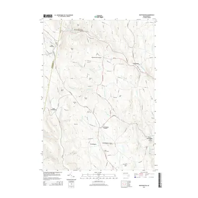
2015 Map of Worthington
USGS Topo · Published 2015About this map
West Br Westfield River and the main Westfield River channel anchor this study of the Hampshire County uplands. The terrain is defined by a series of prominent peaks and family-named landmarks, including Bryant Mtn, Knowles Hill, and Bashan Hill, which overlook a network of tributary streams like Wards Stream and Trout Brook. Settlement patterns are concentrated around historic hubs such as Worthington Corners, Worthington Center, and West Cummington, while the higher elevations remain largely undeveloped. Local history is deeply etched into the landscape through numerous burial grounds, including the East Windsor Cem and the Ireland Road Cem near West Chesterfield. The presence of Albert Farms Airport and the distinct formation of Indian Oven in the southern portion of the map highlight the area's mix of modern utility and geographic curiosity. This region, where the Berkshire Co and Hampshire Co line is clearly marked, preserves a rural character defined by the steep valleys of the West Br and Childs Brook.
Find a feature on this map
130 named features on this map. Tap any name to fly to it.
Don’t see what you’re looking for? This feature index may not catch every label — zoom into the map to look around manually.
Map Details
Editions of this 2015 Worthington Map
This is the sole edition of this map. No revisions or reprints were ever made.
Other maps of this area

1886 · Greylock
USGS Topo · 1:62,500

1886 · Hawley
USGS Topo · 1:62,500

1886 · Chesterfield
USGS Topo · 1:62,500

1886 · Becket
USGS Topo · 1:62,500

1888 · Becket
USGS Topo · 1:62,500

1888 · Chesterfield
USGS Topo · 1:62,500

1890 · Hawley
USGS Topo · 1:62,500

1891 · Greylock
USGS Topo · 1:62,500

1893 · Chesterfield
USGS Topo · 1:62,500

1893 · Becket
USGS Topo · 1:62,500