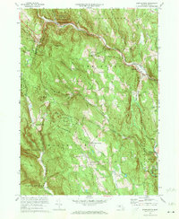
1972 Map of Worthington
USGS Topo · Published 1973About this map
The West Branch Westfield River and Westfield River carve through these Hampshire County highlands, defining a landscape of narrow valleys and prominent peaks. By the early 1970s, the area maintained a balance between its agricultural roots and emerging recreational use, evidenced by the Berkshire Snow Basin Ski Area and Cummington Fairgrounds. The local history of the Bryant Homestead and several family-named landmarks like Starkweather Hill point to deep-seated settlement patterns. Pockets of civic life are centered around Worthington Center and Worthington Corners, while the surrounding hills remain protected within the Worthington State Forest and Peru State Forest. Small rural schools such as the Starkweather Hill Sch and numerous burial grounds, including Dawes Cem and Ireland St Cem, provide essential data points for genealogical research in this part of the Berkshires.
Find a feature on this map
71 named features on this map. Tap any name to fly to it.
Don’t see what you’re looking for? This feature index may not catch every label — zoom into the map to look around manually.
Map Details
Editions of this 1972 Worthington Map
2 editions found

Other maps of this area

1886 · Greylock
USGS Topo · 1:62,500

1886 · Hawley
USGS Topo · 1:62,500

1886 · Chesterfield
USGS Topo · 1:62,500

1886 · Becket
USGS Topo · 1:62,500

1888 · Becket
USGS Topo · 1:62,500

1888 · Chesterfield
USGS Topo · 1:62,500

1890 · Hawley
USGS Topo · 1:62,500

1891 · Greylock
USGS Topo · 1:62,500

1893 · Chesterfield
USGS Topo · 1:62,500

1893 · Becket
USGS Topo · 1:62,500