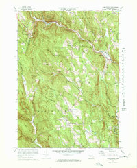
1972 Map of Worthington
USGS Topo · Published 1978About this map
The West Branch Westfield River and its numerous tributaries, including Rivulet Brook and Wards Brook, carve a complex landscape across Hampshire County. In the early 1970s, this area of the Berkshires maintained a balance between recreational development and historical preservation. The Bryant Homestead and Cummington Fairgrounds anchor the eastern side of the quadrangle near Cummington, while the northern hills are home to the Berkshire Snow Basin Ski Area and Deer Hill State Reservation. The settlement pattern follows the river valleys and high ridges, connecting villages like Worthington Corners and West Cummington via winding routes such as Stage Road. Genealogists will find numerous burial grounds scattered across the terrain, from Windsor Cem in the west to the Ireland St Cem near the dramatic rocky features of The Gorge.
Find a feature on this map
69 named features on this map. Tap any name to fly to it.
Don’t see what you’re looking for? This feature index may not catch every label — zoom into the map to look around manually.
Map Details
Editions of this 1972 Worthington Map
2 editions found
Other maps of this area

1886 · Greylock
USGS Topo · 1:62,500

1886 · Hawley
USGS Topo · 1:62,500

1886 · Chesterfield
USGS Topo · 1:62,500

1886 · Becket
USGS Topo · 1:62,500

1888 · Becket
USGS Topo · 1:62,500

1888 · Chesterfield
USGS Topo · 1:62,500

1890 · Hawley
USGS Topo · 1:62,500

1891 · Greylock
USGS Topo · 1:62,500

1893 · Chesterfield
USGS Topo · 1:62,500

1893 · Becket
USGS Topo · 1:62,500