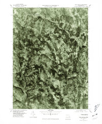
1975 Map of Worthington
USGS Topo · Published 1981About this map
The Westfield River carves a distinct path through this Hampshire County landscape, dictating the development of small settlements during the mid-1970s. This orthophotoquad, derived from aerial photography taken in late 1975, provides a direct visual record of the land use and forest cover surrounding Cummington and West Cummington. The transition from river valley to the higher elevations of the Berkshires is evident in the cluster of small crossroads such as Bryant Four Corners and Worthington Corners. Unlike traditional topographic maps, this imagery-based survey reveals the exact footprint of fields and structures as they existed, offering a clear view of West Worthington and the surrounding woodlands before decades of subsequent growth.
Find a feature on this map
6 named features on this map. Tap any name to fly to it.
Don’t see what you’re looking for? This feature index may not catch every label — zoom into the map to look around manually.
Map Details
Editions of this 1975 Worthington Map
This is the sole edition of this map. No revisions or reprints were ever made.
Other maps of this area

1886 · Greylock
USGS Topo · 1:62,500

1886 · Hawley
USGS Topo · 1:62,500

1886 · Chesterfield
USGS Topo · 1:62,500

1886 · Becket
USGS Topo · 1:62,500

1888 · Becket
USGS Topo · 1:62,500

1888 · Chesterfield
USGS Topo · 1:62,500

1890 · Hawley
USGS Topo · 1:62,500

1891 · Greylock
USGS Topo · 1:62,500

1893 · Chesterfield
USGS Topo · 1:62,500

1893 · Becket
USGS Topo · 1:62,500