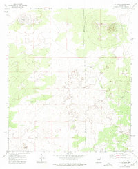
1972 Map of X-7 Ranch
USGS Topo · Published 1975About this map
The boundary between Luna County and Doña Ana County bisects this ranching landscape as it appeared in the early 1970s. This arid stretch of New Mexico is defined by the isolated operations of the X-7 Ranch, which includes a dedicated Landing Strip, signaling the scale and logistical needs of high-desert livestock management in this era. The topography is marked by volcanic features like Malpais Ridge and the ephemeral San Luis Lake, while man-made water sources such as the San Pedro Windmill and Sweetwater Windmill provided the essential infrastructure for survival in a region with few natural springs. The map documents a sparse but deliberate network of unimproved roads and fence lines that connect these remote outposts.
Find a feature on this map
7 named features on this map. Tap any name to fly to it.
Don’t see what you’re looking for? This feature index may not catch every label — zoom into the map to look around manually.
Map Details
Editions of this 1972 X-7 Ranch Map
This is the sole edition of this map. No revisions or reprints were ever made.
Other maps of this area

1917 · Camel Mountain
USGS Topo · 1:62,500

1917 · Mt. Riley
USGS Topo · 1:62,500

1918 · Mt. Riley
USGS Topo · 1:62,500

1929 · Mt. Riley
USGS Topo · 1:62,500

1941 · Aden
USGS Topo · 1:62,500

1943 · Aden
USGS Topo · 1:62,500

1951 · Mt. Riley
USGS Topo · 1:62,500

1953 · El Paso
USGS Topo · 1:250,000

1955 · Las Cruces
USGS Topo · 1:250,000

1958 · Las Cruces
USGS Topo · 1:250,000