1996 Map of Yap Islands (Waqab)
USGS Topo · Published 2003About this map
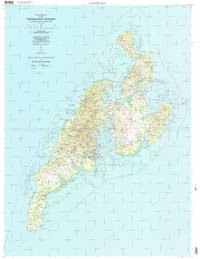
The main administrative center of Colonia and its surrounding villages are meticulously charted in this study of the Yap Islands (Waqab). The map reveals a traditional settlement pattern where communities like Wanyan, Gachpar, and Balebaat are connected by a growing infrastructure, including the Yap International Airport. Deep cultural and social history is visible through the placement of landmarks such as Saint Francis of Assisi Church and Saint Joseph Church, alongside educational centers like the Rumung School and Gaanelay School.
Find a feature on this map
54 named features on this map. Tap any name to fly to it.
Don’t see what you’re looking for? This feature index may not catch every label — zoom into the map to look around manually.
Map Details
Editions of this 1996 Yap Islands (Waqab) Map
This is the sole edition of this map. No revisions or reprints were ever made.