Old Maps of Nett, Pohnpei for Genealogy
Trace your family roots with 6 historic maps of Nett. These high-res maps reveal old neighborhoods, homesites, landmarks, and streets — helping you uncover where your ancestors lived and how the area evolved over time.
- Explore historic neighborhoods: Identify where your relatives may have lived in the 1800s or 1900s.
- Compare maps over time: Trace the changes in streets, buildings, and landmarks for multi-generational research.
- Perfect for genealogy & ancestry research: Used by family historians and researchers to map out lineage and migration.
These maps are an incredible resource for exploring your personal connection to Nett's past.
Nett, PNI maps
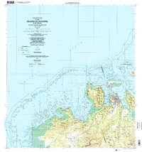
(6)- 1983 Map of Island Of Ponape (North Half)
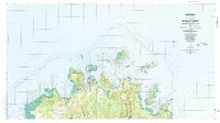 1983 Island Of Ponape (North Half)1983 Print · USGSThe northern coast of Ponape in the early eighties shows the administrative center of Kolonia amidst a landscape of steep volcanic peaks and vast coral reefs. Genealogists and researchers can trace local settlements like Palikir and Ohwa or locate landmarks such as the Radio Towers.
 - 1983 Map of Island Of Ponape (South Half)
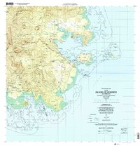
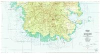 1983 Island Of Ponape (South Half)1983 Print · USGSMicronesia’s southern coastlines and interior peaks are recorded here in the early 1980s, shortly after the formation of the Federated States. Researchers can trace coastal villages from Pahn Kiper to Tomwara and the essential local Dispensary.
 - 2001 Map of Island Of Pohnpei (Southwest), 2002 Print
 2001 Island Of Pohnpei (Southwest)2002 Print · USGSThe southwestern coast of Pohnpei is captured here at the start of the millennium, showing a landscape defined by its protected marine zones and forest reserves. Researchers can trace the coastal settlements of Sekeren and Wenik or locate landmarks like the southern Dispensary.
 - 2001 Map of Island Of Pohnpei (Northeast), 2002 Print
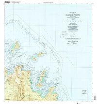 2001 Island Of Pohnpei (Northeast)2002 Print · USGSNortheastern Pohnpei in the early 2000s showcases a balance of village life and vital maritime conservation areas. Researchers can trace traditional coastal settlements like Kepin Ketiwo and Nindol alongside the Dehpehk Marine Sanctuary and the islands of Deke Awah.
 - 2001 Map of Island Of Pohnpei (Northwest), 2002 Print
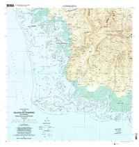
 2001 Island Of Pohnpei (Northwest)2002 Print · USGSNorthwest Pohnpei at the turn of the millennium showcases the expansion of Kolonia alongside protected natural reaches. Researchers can trace the development of the Pohnpei International Airport and locate traditional settlements like Sapwawas and Palikir.
 - 2001 Map of Island Of Pohnpei (Southeast), 2002 Print
 2001 Island Of Pohnpei (Southeast)2002 Print · USGSSoutheastern Pohnpei at the opening of the millennium shows a landscape where protected forest reserves meet thriving coastal reef systems. Researchers can trace local settlements from Dolrakied to Lohd Pawe and locate marine protected areas like the Namwen Na Na Marine Sanctuary.
End of results
Showing maps 1-6 of 6
Top neighborhoods of Nett
Frequently asked questions
- What are the different types of historical maps available for Nett?
- What is the oldest map of Nett?
- Where can I purchase historical maps of Nett for my home or office?
- Where can I download high-res historical maps of Nett?
- Are there historical topographic maps available for Nett?
- Is there historical aerial imagery available for Nett?
- Where are historical maps of Nett sourced from?