Old Maps of Colonia, Weeloey for Metal Detecting
Plan your next treasure hunt with 2 historic maps of Colonia. Find old homesites, ghost towns, trails, and gathering spots that may be lost to time — perfect for identifying promising metal detecting locations.
- Locate forgotten sites: Uncover places like long-lost settlements, abandoned rail lines, or gathering spots.
- Plan better hunts: Use map overlays combined with LiDAR or satellite views to narrow in on historically rich areas.
- Made for detectorists: Thousands of hobbyists use these maps to discover relics, coins, and hidden history.
Use these historic maps to boost your research and find new opportunities beneath the surface of Colonia.
Colonia, Weeloey maps
(2)- 1983 Map of Yap Islands (Waqab)
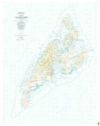 1983 Yap Islands (Waqab)1983 Print · USGSThe Yap Islands are captured in the early eighties as they transitioned into a new era of self-governance. Researchers can trace traditional village sites like Gagnagun and Bechiyal or locate landmarks such as St Josephs Church and the Yap Airport.
 - 1996 Map of Yap Islands (Waqab), 2003 Print
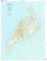 1996 Yap Islands (Waqab)2003 Print · USGSThe Yap Islands in the mid-1990s show a blend of traditional village life and modern infrastructure across the Federated States of Micronesia. Researchers can trace the coastal layout of Colonia, locate specific mission sites like Saint Joseph Church, and find historic Fish Traps near Wanyan.
End of results
Showing maps 1-2 of 2
Frequently asked questions
- What are the different types of historical maps available for Colonia?
- What is the oldest map of Colonia?
- Where can I purchase historical maps of Colonia for my home or office?
- Where can I download high-res historical maps of Colonia?
- Are there historical topographic maps available for Colonia?
- Is there historical aerial imagery available for Colonia?
- Where are historical maps of Colonia sourced from?