2000s (21st Century) Maps of Guam
Explore 9 historic maps of Guam from the 2000s (21st Century). These maps offer a rare glimpse into what life looked like during the 2000s — showing old roads, neighborhoods, homes, and landmarks that have changed or disappeared over time.
Whether you're researching your family's past, planning a metal detecting trip, or studying how Guam's landscape evolved across the 2000s, these high-resolution maps are a powerful tool for exploring the history of this region.
- Focus on a specific era: All maps on this page are from the 2000s, giving you a focused view of this time period.
- See what’s changed: Compare century-old streets, trails, and buildings to today's modern landscape using overlays and satellite layers.
- Research with precision: Use these maps for genealogy, historical research, land use analysis, or educational projects.
- View, download, or print: Maps are fully viewable online in high resolution, and can be downloaded or printed for your own records.
Start exploring Guam's history through authentic maps from the 2000s. This is your window into the past.
Guam maps
(9)- 2000 Map of Dededo, 2002 Print
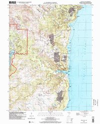
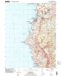
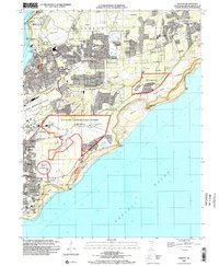 2000 Dededo2002 Print · USGSNorthern Guam at the turn of the millennium shows a landscape defined by rapid suburban growth and significant military presence. Researchers can trace local landmarks like the War Dog Cemetery, the Micronesia Mall, and several villages including Harmon Village and Asatdas.
 - 2000 Map of Inarajan, 2002 Print
 2000 Inarajan2002 Print · USGSSouthern Guam at the turn of the millennium reveals a traditional landscape of coastal villages and reef-protected bays. Researchers can trace local genealogy and land use through landmarks like Inarajan Cemetery, Inarajan Middle School, and the University of Guam Agricultural Experiment Station.
 - 2000 Map of Ritidian Point, 2002 Print
 2000 Ritidian Point2002 Print · USGSNorthern Guam at the turn of the millennium shows a landscape defined by critical military installations and growing residential villages. Genealogists and historians can locate Machananao School, the South Finegayan Housing (USN), and family landmarks near Mataguac.
 - 2000 Map of Apra Harbor, 2002 Print
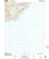
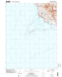
 2000 Apra Harbor2002 Print · USGSThe strategic waters of Guam are captured here at the turn of the millennium, showing the dense military and commemorative landscape of the Orote Peninsula. Trace local history at the Sumay Cemetery Japanese Caves, the US Naval Cemetery, and the Fort Santa Cruz (Site).
 - 2000 Map of Talofofo, 2002 Print
 2000 Talofofo2002 Print · USGSSoutheastern Guam at the turn of the century shows a blend of growing coastal villages and inland institutional sites. Genealogists and researchers can trace local landmarks like Saint Francis Church, the NASA Tracking Station, and community sites such as Talofofo School.
 - 2000 Map of Pati Point, 2002 Print
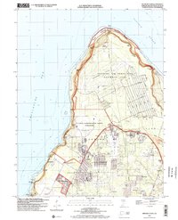
 2000 Pati Point2002 Print · USGSGuam at the turn of the millennium reveals a landscape defined by the intersection of military operations and coastal geography. Researchers can trace base infrastructure like Gilkeson Field alongside local landmarks like Upi School and Mount Santa Rosa.
 - 2000 Map of Hagatna, 2002 Print
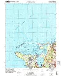
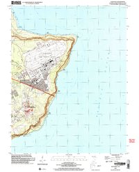
 2000 Hagatna2002 Print · USGSGuam's capital and its surrounding municipalities are shown in detail at the start of the twenty-first century. Researchers can trace local landmarks like Pigo Cem, the Hagatna Detention Facility, and schools ranging from Tamuning School to the University of Guam Marine Laboratory.
 - 2000 Map of Merizo, 2002 Print
 2000 Merizo2002 Print · USGSSouthern Guam at the turn of the millennium reveals a coastal landscape shaped by its coral reefs and steep volcanic ridges. Genealogists and local historians can locate Bingot Cemetery, the Merizo Martyrs Monument, and the coastal village of Merizo.
 - 2000 Map of Agat, 2002 Print
 2000 Agat2002 Print · USGSThe southwestern coast of Guam at the turn of the millennium shows a landscape shared by naval installations and historic Chamorro villages. Trace Spanish-era relics like the Old Spanish Bridge and Fort Soledad alongside modern sites like Santa Rita.
End of results
Showing maps 1-9 of 9
Top cities of Guam
Frequently asked questions
- What are the different types of historical maps available for Guam?
- What is the oldest map of Guam?
- Where can I purchase historical maps of Guam for my home or office?
- Where can I download high-res historical maps of Guam?
- Are there historical topographic maps available for Guam?
- Is there historical aerial imagery available for Guam?
- Where are historical maps of Guam sourced from?