2000 Map of Dededo
USGS Topo · Published 2002About this map
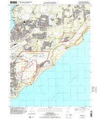
Dededo and its surrounding villages stand as a central hub of Guam's northern plateau, showing the intense post-war development of the island's infrastructure. The landscape is characterized by a high density of civic and military facilities, from the Guam International Airport to the expansive Andersen Air Force Base and the U S Naval Communication Station Barrigada. This era of the island's history is reflected in the numerous schools, such as the Vicente S A Benavente Middle School and Daniel L Perez School, which anchor the growing residential districts.
Find a feature on this map
79 named features on this map. Tap any name to fly to it.
Don’t see what you’re looking for? This feature index may not catch every label — zoom into the map to look around manually.
Map Details
Editions of this 2000 Dededo Map
This is the sole edition of this map. No revisions or reprints were ever made.
Other maps of this area
Featured Places
- Dededo, Dededo Municipality
- Mangilao, Mangilao Municipality
- Tiyan, Barrigada Municipality
- Finegayan Station, Dededo Municipality
- Astumbo, Dededo Municipality