Loading...
Loading map...2000 Map of Pati Point
USGS Topo · Published 2002About this map
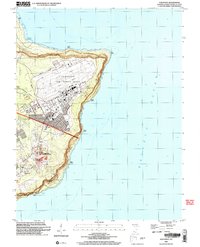
Andersen Air Force Base dominates the northern plateau of Guam in this turn-of-the-century topographic record. The base is shown with detailed infrastructure, including 33d Street, Madison Avenue, and Gilkeson Field. The landscape is a mix of high-security military zones and the island's natural coastal features, such as the coral reefs surrounding Pati Point and Tarague Beach.
Find a feature on this map
43 named features on this map. Tap any name to fly to it.
Don’t see what you’re looking for? This feature index may not catch every label — zoom into the map to look around manually.
Map Details
Date Portrayed2000
Date Published2002
PublisherU.S. Geological Survey
Map TypeTopographic
Scale1:24,000
Physical Dimensions21.49 x 26.57 inches
Editions of this 2000 Pati Point Map
This is the sole edition of this map. No revisions or reprints were ever made.
Other maps of this area
Featured Places
Source Details
SourceU.S. Geological Survey
CopyrightPublic Domain