Old Maps of Yigo, Yigo Municipality
Explore 3 old maps of Yigo, spanning from 2000 to today. These high-resolution historic maps reveal how streets, neighborhoods, landmarks, and natural features evolved over time — perfect for genealogy, metal detecting, research, and local history exploration.
What you can do with these maps:
- See how Yigo changed over time: Compare historical maps to modern-day views to trace roads, homesites, rail lines & more.
- View detailed metadata: Each map includes creators, publishers, year, scale, and archive source.
- Overlay maps with satellite & LiDAR: Visualize the past alongside modern tools to explore terrain & human change.
- Trusted historical sources: Maps sourced from the USGS, Library of Congress, and other archives.
- Access maps your way: View online, download high-res files, or order prints for personal or research use.
Start exploring old maps of Yigo to uncover forgotten places, hidden landmarks, and the deep history beneath your feet.
Yigo, Yigo Municipality maps
(3)- 2000 Map of Dededo, 2002 Print
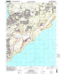 2000 Dededo2002 Print · USGSNorthern Guam at the turn of the millennium shows a landscape defined by rapid suburban growth and significant military presence. Researchers can trace local landmarks like the War Dog Cemetery, the Micronesia Mall, and several villages including Harmon Village and Asatdas.
 - 2000 Map of Ritidian Point, 2002 Print
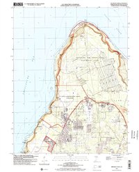 2000 Ritidian Point2002 Print · USGSNorthern Guam at the turn of the millennium shows a landscape defined by critical military installations and growing residential villages. Genealogists and historians can locate Machananao School, the South Finegayan Housing (USN), and family landmarks near Mataguac.
 - 2000 Map of Pati Point, 2002 Print
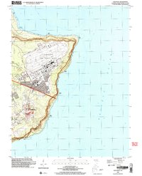 2000 Pati Point2002 Print · USGSGuam at the turn of the millennium reveals a landscape defined by the intersection of military operations and coastal geography. Researchers can trace base infrastructure like Gilkeson Field alongside local landmarks like Upi School and Mount Santa Rosa.
End of results
Showing maps 1-3 of 3
Top cities near Yigo
Frequently asked questions
- What are the different types of historical maps available for Yigo?
- What is the oldest map of Yigo?
- Where can I purchase historical maps of Yigo for my home or office?
- Where can I download high-res historical maps of Yigo?
- Are there historical topographic maps available for Yigo?
- Is there historical aerial imagery available for Yigo?
- Where are historical maps of Yigo sourced from?