2000 Map of Ritidian Point
USGS Topo · Published 2002About this map
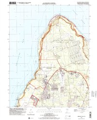
Ritidian Point defines the northernmost tip of Guam, where the Philippine Sea meets the Pacific Ocean at the Ritidian Channel. This area of the island is heavily shaped by its strategic military and communications role, featuring the Abandoned Andersen Air Force Base (Northwest Field) and the U S Naval Communication Station Finegayan. Beyond the coastal cliffs and the Guam National Wildlife Refuge, the landscape transitions into the residential and agricultural reaches of Dededo and Yigo. The presence of multiple schools, including Astumbo School and Machananao School, alongside settlements like Agafo Gumas and Oceanview, illustrates the post-war growth of northern Guam. Notable landmarks such as the Guam Observatory and Federal Aviation Agency Headquarters sit alongside local features like the Mataguac Spring and the Guam Golf Resort, marking the intersection of federal utility and local community life.
Find a feature on this map
59 named features on this map. Tap any name to fly to it.
Don’t see what you’re looking for? This feature index may not catch every label — zoom into the map to look around manually.
Map Details
Editions of this 2000 Ritidian Point Map
This is the sole edition of this map. No revisions or reprints were ever made.
Other maps of this area
Featured Places
- Finegayan Station, Dededo Municipality
- Astumbo, Dededo Municipality
- Andersen Air Force Base, Yigo Municipality
- Yigo, Yigo Municipality
- Guam