2000 Map of Talofofo
USGS Topo · Published 2002About this map
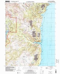
The coastal village of Talofofo and the surrounding heights of Yona define this eastern landscape of Guam as it appeared at the turn of the millennium. The map illustrates a transition from the dense river systems of the interior, including the Talofofo River and Ugum River, to the recreational and residential developments along the Pacific Ocean coast. Significant institutional presence is visible through the Guam Adventist Academy, Notre Dame High School, and the NASA Tracking Station located near the southern reaches of Sabana Maagazine. Large-scale land use is dominated by leisure and military facilities, ranging from the Talofofo Golf Resort and Windward Hills Country Club to the Naval Reservation areas. Local community life is anchored by landmarks like Saint Francis Church and the Manuel U Lujan School, while the rugged coastline is marked by named geographic points such as Asanite Point and Jalaihai Point.
Find a feature on this map
94 named features on this map. Tap any name to fly to it.
Don’t see what you’re looking for? This feature index may not catch every label — zoom into the map to look around manually.
Map Details
Editions of this 2000 Talofofo Map
This is the sole edition of this map. No revisions or reprints were ever made.
Other maps of this area
Featured Places
- Chalan Pago, Chalan Pago-Ordot Municipality
- Yona, Yona Municipality
- Talofofo, Talo’fo’fo’ Municipality
- Guam
- Sånta Rita-Sumai Municipality