Loading...
Loading map...2000 Map of Merizo
USGS Topo · Published 2002About this map
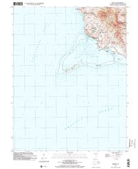
Cocos Island and its surrounding coral reefs anchor this study of Guam's southern coastline at the start of the 21st century. The map details the village of Merizo, showing a concentration of community landmarks including the Merizo Martyrs Memorial School and the Merizo Martyrs Monument. This area is defined by its relationship with the water, where the Cocos Lagoon is protected by a series of reefs and navigated through the Mamaon Channel and Merizo Channel.
Find a feature on this map
51 named features on this map. Tap any name to fly to it.
Don’t see what you’re looking for? This feature index may not catch every label — zoom into the map to look around manually.
Map Details
Date Portrayed2000
Date Published2002
PublisherU.S. Geological Survey
Map TypeTopographic
Scale1:24,000
Physical Dimensions21.7 x 26.7 inches
Editions of this 2000 Merizo Map
This is the sole edition of this map. No revisions or reprints were ever made.
Other maps of this area
Featured Places
Source Details
SourceU.S. Geological Survey
CopyrightPublic Domain