2000 Map of Agat
USGS Topo · Published 2002About this map
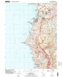
Agat and the southwestern coast of Guam are defined by a mix of military infrastructure, local villages, and deep historical sites at the start of the 21st century. The map highlights significant cultural remnants, including the Old Spanish Bridge and several fortifications such as Fort Soledad and Fort San Jose overlooking Umatac Bay. To the north, the Apra Harbor Naval Reservation and US Naval Magazine represent the extensive naval presence that shaped development in Santa Rita and Agat. Between these centers, the rugged ridgeline is punctuated by high points like Mount Lamlam and Mount Jumullong Manglo, while protected lands within the War in the Pacific National Historical Park preserve coastal battlegrounds at Gaan Point and Bangi Point.
Find a feature on this map
88 named features on this map. Tap any name to fly to it.
Don’t see what you’re looking for? This feature index may not catch every label — zoom into the map to look around manually.
Map Details
Editions of this 2000 Agat Map
This is the sole edition of this map. No revisions or reprints were ever made.
Other maps of this area
Featured Places
- Hågat, Agat
- Santa Rosa, Sånta Rita-Sumai Municipality
- Santa Rita, Sånta Rita-Sumai Municipality
- Agat
- Umatac