Loading...
Loading map...2000 Map of Apra Harbor
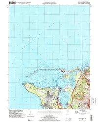
USGS Topo · Published 2002About this map
Apra Harbor Naval Reservation anchors this Pacific maritime landscape, documenting a critical hub of naval infrastructure and historic conflict. On the southern edge of the harbor, the legacy of Sumay remains visible near the Guam Airfield (Abandoned) and Lockwood Terrace. The map carefully notes cultural and military layers, including the US Naval Cemetery and Sumay Cemetery Japanese Caves, alongside several units of the War in the Pacific National Historic Park.
Find a feature on this map
57 named features on this map. Tap any name to fly to it.
Don’t see what you’re looking for? This feature index may not catch every label — zoom into the map to look around manually.
Map Details
Date Portrayed2000
Date Published2002
PublisherU.S. Geological Survey
Map TypeTopographic
Scale1:24,000
Physical Dimensions21.5 x 26.7 inches
Editions of this 2000 Apra Harbor Map
This is the sole edition of this map. No revisions or reprints were ever made.
Other maps of this area
Featured Places
Source Details
SourceU.S. Geological Survey
CopyrightPublic Domain