2000 Map of Inarajan
USGS Topo · Published 2002About this map
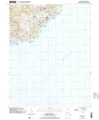
The coastal village of Inarajan serves as the heart of this Southern Guam survey, illustrating a landscape where steep ridges meet the complex reef systems of the Pacific. Local infrastructure is anchored by the Inarajan School, Inarajan Middle School, and the Inarajan Cemetery, while agricultural research is represented by the University of Guam Agricultural Experiment Station near Mulona. The terrain is deeply incised by watercourses like the Inarajan River and Agfayan River, which terminate in protected waters such as Inarajan Bay and Agfayan Bay.
Find a feature on this map
76 named features on this map. Tap any name to fly to it.
Don’t see what you’re looking for? This feature index may not catch every label — zoom into the map to look around manually.
Map Details
Editions of this 2000 Inarajan Map
This is the sole edition of this map. No revisions or reprints were ever made.