Old Maps of Agat for Academic Research
Study the evolution of Agat with 1 high-resolution historic maps. Whether you're teaching, researching, or modeling changes in land use, these maps provide essential visual documentation of urban, environmental, and geographic change.
- Analyze long-term change: Track patterns in development, transportation, and natural features.
- Ideal for environmental or urban studies: Support academic projects with primary historical map data.
- Use in the classroom or lab: Educators and researchers rely on these maps to bring historical context to life.
These maps are a powerful tool for teaching, research, and visualizing how Agat has changed over the decades.
Agat maps
(1)- 2000 Map of Agat, 2002 Print
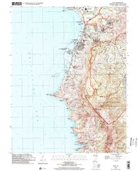 2000 Agat2002 Print · USGSThe southwestern coast of Guam at the turn of the millennium shows a landscape shared by naval installations and historic Chamorro villages. Trace Spanish-era relics like the Old Spanish Bridge and Fort Soledad alongside modern sites like Santa Rita.
End of results
Showing maps 1-1 of 1
Top cities near Agat
Top neighborhoods of Agat
Frequently asked questions
- What are the different types of historical maps available for Agat?
- What is the oldest map of Agat?
- Where can I purchase historical maps of Agat for my home or office?
- Where can I download high-res historical maps of Agat?
- Are there historical topographic maps available for Agat?
- Is there historical aerial imagery available for Agat?
- Where are historical maps of Agat sourced from?