Old Maps of Hågat, Agat for Genealogy
Trace your family roots with 1 historic maps of Hågat. These high-res maps reveal old neighborhoods, homesites, landmarks, and streets — helping you uncover where your ancestors lived and how the area evolved over time.
- Explore historic neighborhoods: Identify where your relatives may have lived in the 1800s or 1900s.
- Compare maps over time: Trace the changes in streets, buildings, and landmarks for multi-generational research.
- Perfect for genealogy & ancestry research: Used by family historians and researchers to map out lineage and migration.
These maps are an incredible resource for exploring your personal connection to Hågat's past.
Hågat, Agat maps
(1)- 2000 Map of Agat, 2002 Print
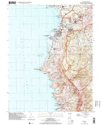 2000 Agat2002 Print · USGSThe southwestern coast of Guam at the turn of the millennium shows a landscape shared by naval installations and historic Chamorro villages. Trace Spanish-era relics like the Old Spanish Bridge and Fort Soledad alongside modern sites like Santa Rita.
End of results
Showing maps 1-1 of 1
Top cities near Hågat
Frequently asked questions
- What are the different types of historical maps available for Hågat?
- What is the oldest map of Hågat?
- Where can I purchase historical maps of Hågat for my home or office?
- Where can I download high-res historical maps of Hågat?
- Are there historical topographic maps available for Hågat?
- Is there historical aerial imagery available for Hågat?
- Where are historical maps of Hågat sourced from?