Old Maps of Inalåhan Municipality for Hiking & Exploration
Hike through history with 4 historic maps of Inalåhan Municipality. Explore old trails, ghost towns, and forgotten backroads — perfect for outdoor adventurers and local explorers.
- Rediscover forgotten places: Map out old mining camps, roads, and footpaths that no longer exist on modern maps.
- Layer with modern tools: Combine with LiDAR or satellite views to plan hikes through historical terrain.
- Made for exploration: Popular among hikers, overlanders, and local history lovers.
Use these maps to find adventure and explore the hidden past of Inalåhan Municipality.
Inalåhan Municipality maps
(4)- 2000 Map of Inarajan, 2002 Print
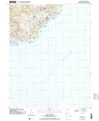 2000 Inarajan2002 Print · USGSSouthern Guam at the turn of the millennium reveals a traditional landscape of coastal villages and reef-protected bays. Researchers can trace local genealogy and land use through landmarks like Inarajan Cemetery, Inarajan Middle School, and the University of Guam Agricultural Experiment Station.
 - 2000 Map of Talofofo, 2002 Print
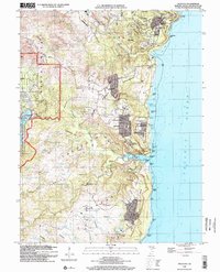 2000 Talofofo2002 Print · USGSSoutheastern Guam at the turn of the century shows a blend of growing coastal villages and inland institutional sites. Genealogists and researchers can trace local landmarks like Saint Francis Church, the NASA Tracking Station, and community sites such as Talofofo School.
 - 2000 Map of Merizo, 2002 Print
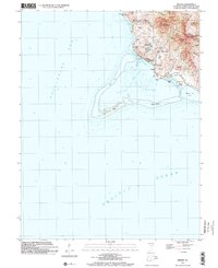 2000 Merizo2002 Print · USGSSouthern Guam at the turn of the millennium reveals a coastal landscape shaped by its coral reefs and steep volcanic ridges. Genealogists and local historians can locate Bingot Cemetery, the Merizo Martyrs Monument, and the coastal village of Merizo.
 - 2000 Map of Agat, 2002 Print
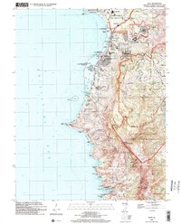 2000 Agat2002 Print · USGSThe southwestern coast of Guam at the turn of the millennium shows a landscape shared by naval installations and historic Chamorro villages. Trace Spanish-era relics like the Old Spanish Bridge and Fort Soledad alongside modern sites like Santa Rita.
End of results
Showing maps 1-4 of 4
Frequently asked questions
- What are the different types of historical maps available for Inalåhan Municipality?
- What is the oldest map of Inalåhan Municipality?
- Where can I purchase historical maps of Inalåhan Municipality for my home or office?
- Where can I download high-res historical maps of Inalåhan Municipality?
- Are there historical topographic maps available for Inalåhan Municipality?
- Is there historical aerial imagery available for Inalåhan Municipality?
- Where are historical maps of Inalåhan Municipality sourced from?