Old Maps of Yigo Municipality for Metal Detecting
Plan your next treasure hunt with 3 historic maps of Yigo Municipality. Find old homesites, ghost towns, trails, and gathering spots that may be lost to time — perfect for identifying promising metal detecting locations.
- Locate forgotten sites: Uncover places like long-lost settlements, abandoned rail lines, or gathering spots.
- Plan better hunts: Use map overlays combined with LiDAR or satellite views to narrow in on historically rich areas.
- Made for detectorists: Thousands of hobbyists use these maps to discover relics, coins, and hidden history.
Use these historic maps to boost your research and find new opportunities beneath the surface of Yigo Municipality.
Yigo Municipality maps
(3)- 2000 Map of Dededo, 2002 Print
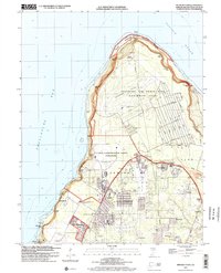
 2000 Dededo2002 Print · USGSNorthern Guam at the turn of the millennium shows a landscape defined by rapid suburban growth and significant military presence. Researchers can trace local landmarks like the War Dog Cemetery, the Micronesia Mall, and several villages including Harmon Village and Asatdas.
 - 2000 Map of Ritidian Point, 2002 Print
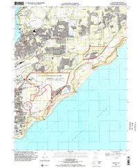
 2000 Ritidian Point2002 Print · USGSNorthern Guam at the turn of the millennium shows a landscape defined by critical military installations and growing residential villages. Genealogists and historians can locate Machananao School, the South Finegayan Housing (USN), and family landmarks near Mataguac.
 - 2000 Map of Pati Point, 2002 Print
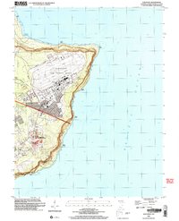 2000 Pati Point2002 Print · USGSGuam at the turn of the millennium reveals a landscape defined by the intersection of military operations and coastal geography. Researchers can trace base infrastructure like Gilkeson Field alongside local landmarks like Upi School and Mount Santa Rosa.
End of results
Showing maps 1-3 of 3
Frequently asked questions
- What are the different types of historical maps available for Yigo Municipality?
- What is the oldest map of Yigo Municipality?
- Where can I purchase historical maps of Yigo Municipality for my home or office?
- Where can I download high-res historical maps of Yigo Municipality?
- Are there historical topographic maps available for Yigo Municipality?
- Is there historical aerial imagery available for Yigo Municipality?
- Where are historical maps of Yigo Municipality sourced from?