1900s (20th Century) Maps of Koror
Explore 6 historic maps of Koror from the 1900s (20th Century). These maps offer a rare glimpse into what life looked like during the 1900s — showing old roads, neighborhoods, homes, and landmarks that have changed or disappeared over time.
Whether you're researching your family's past, planning a metal detecting trip, or studying how Koror's landscape evolved across the 1900s, these high-resolution maps are a powerful tool for exploring the history of this region.
- Focus on a specific era: All maps on this page are from the 1900s, giving you a focused view of this time period.
- See what’s changed: Compare century-old streets, trails, and buildings to today's modern landscape using overlays and satellite layers.
- Research with precision: Use these maps for genealogy, historical research, land use analysis, or educational projects.
- View, download, or print: Maps are fully viewable online in high resolution, and can be downloaded or printed for your own records.
Start exploring Koror's history through authentic maps from the 1900s. This is your window into the past.
Koror maps
(6)- 1983 Map of Oreor, 1984 Print
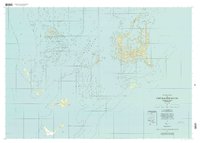
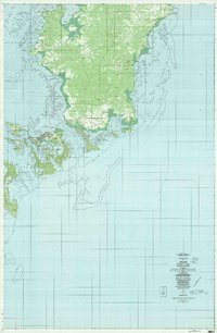 1983 Oreor1984 Print · USGSThe islands of Palau are shown during a period of significant development in the early eighties. Researchers can trace the layout of traditional villages like Ngerkesoaol and Ngermid alongside the site of the Palau Airport.
 - 1984 Map of Chelbacheb
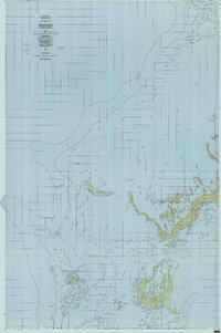 1984 Chelbacheb1984 Print · USGSThe limestone islands of the Palau archipelago are mapped here in the mid-eighties, revealing a complex network of reefs and lagoons. Researchers can chart the boundaries of the Ngerokeuid Wildlife Reservation Area or trace waterways like Klouel Toi and Toachel Belau.
 - 1984 Map of Beliliou
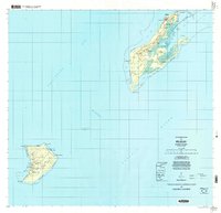
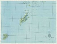 1984 Beliliou1984 Print · USGSThe Republic of Palau is captured in the mid-eighties, showing the detailed geography of the southern islands and coral reefs. Researchers can trace the topography of Bloody Nose Ridge and locate settlements like Kloulklubed and Ngeaur.
 - 1998 Map of Chelbacheb North, 2004 Print
 1998 Chelbacheb North2004 Print · USGSThe northern Rock Islands of Palau are captured in exceptional detail during the late 1990s, showcasing a complex seascape of limestone karst and coral reefs. Researchers can trace traditional place names and coastal landmarks like Ngeruktabel, the Natural Arch, and Ulong.
 - 1998 Map of Chelbacheb South, 2004 Print
 1998 Chelbacheb South2004 Print · USGSThe Chelbacheb or Rock Islands are documented here in the late nineties, showcasing the complex coral reef and limestone formations of Palau. Researchers can trace the protected waters of the Ngerukewid Islands Wildlife Preserve and landmarks like Eil Malk and Ngerechong.
 - 1999 Map of Peleliu, 2004 Print
 1999 Peleliu2004 Print · USGSPeleliu and Angaur are mapped here during the late twentieth century, showing the enduring geography of these Pacific islands. Local historians can trace landmarks like Bloody Nose Ridge, the Historical Marker, and Our Lady of the Rosary Church.
End of results
Showing maps 1-6 of 6
Top cities of Koror
Frequently asked questions
- What are the different types of historical maps available for Koror?
- What is the oldest map of Koror?
- Where can I purchase historical maps of Koror for my home or office?
- Where can I download high-res historical maps of Koror?
- Are there historical topographic maps available for Koror?
- Is there historical aerial imagery available for Koror?
- Where are historical maps of Koror sourced from?