2000-2009 Maps of Ngiwal
Explore 2 historic maps of Ngiwal from 2000-2009. These maps offer a rare glimpse into what life looked like during the 2000s — showing old roads, neighborhoods, homes, and landmarks that have changed or disappeared over time.
Whether you're researching your family's past, planning a metal detecting trip, or studying how Ngiwal's landscape evolved across the 2000s, these high-resolution maps are a powerful tool for exploring the history of this region.
- Focus on a specific era: All maps on this page are from the 2000s, giving you a focused view of this time period.
- See what’s changed: Compare century-old streets, trails, and buildings to today's modern landscape using overlays and satellite layers.
- Research with precision: Use these maps for genealogy, historical research, land use analysis, or educational projects.
- View, download, or print: Maps are fully viewable online in high resolution, and can be downloaded or printed for your own records.
Start exploring Ngiwal's history through authentic maps from the 2000s. This is your window into the past.
Ngiwal maps
(2)- 2000 Map of Babeldaob North, 2004 Print
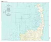 2000 Babeldaob North2004 Print · USGSNorthern Babeldaob Island at the start of the century reveals a coastal landscape of coral reefs and ridge-top villages. Researchers can locate community landmarks like Bethany church or trace the shoreline from Bkul a Ngesang to Ollei.
 - 2000 Map of Babeldaob South, 2004 Print
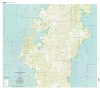 2000 Babeldaob South2004 Print · USGSBabeldaob Island at the turn of the millennium reveals a traditional landscape of coastal villages and protected interior highlands. Researchers can trace the development of settlements like Melekeok and Airai, or locate local landmarks such as the Ngchesar School and the Ngeremeduu Conservation Area.
End of results
Showing maps 1-2 of 2
Frequently asked questions
- What are the different types of historical maps available for Ngiwal?
- What is the oldest map of Ngiwal?
- Where can I purchase historical maps of Ngiwal for my home or office?
- Where can I download high-res historical maps of Ngiwal?
- Are there historical topographic maps available for Ngiwal?
- Is there historical aerial imagery available for Ngiwal?
- Where are historical maps of Ngiwal sourced from?