Old Maps of Peleliu for Academic Research
Study the evolution of Peleliu with 4 high-resolution historic maps. Whether you're teaching, researching, or modeling changes in land use, these maps provide essential visual documentation of urban, environmental, and geographic change.
- Analyze long-term change: Track patterns in development, transportation, and natural features.
- Ideal for environmental or urban studies: Support academic projects with primary historical map data.
- Use in the classroom or lab: Educators and researchers rely on these maps to bring historical context to life.
These maps are a powerful tool for teaching, research, and visualizing how Peleliu has changed over the decades.
Peleliu maps
(4)- 1984 Map of Chelbacheb
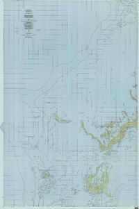 1984 Chelbacheb1984 Print · USGSThe limestone islands of the Palau archipelago are mapped here in the mid-eighties, revealing a complex network of reefs and lagoons. Researchers can chart the boundaries of the Ngerokeuid Wildlife Reservation Area or trace waterways like Klouel Toi and Toachel Belau.
 - 1984 Map of Beliliou
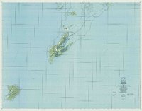 1984 Beliliou1984 Print · USGSThe Republic of Palau is captured in the mid-eighties, showing the detailed geography of the southern islands and coral reefs. Researchers can trace the topography of Bloody Nose Ridge and locate settlements like Kloulklubed and Ngeaur.
 - 1998 Map of Chelbacheb South, 2004 Print
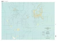 1998 Chelbacheb South2004 Print · USGSThe Chelbacheb or Rock Islands are documented here in the late nineties, showcasing the complex coral reef and limestone formations of Palau. Researchers can trace the protected waters of the Ngerukewid Islands Wildlife Preserve and landmarks like Eil Malk and Ngerechong.
 - 1999 Map of Peleliu, 2004 Print
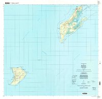 1999 Peleliu2004 Print · USGSPeleliu and Angaur are mapped here during the late twentieth century, showing the enduring geography of these Pacific islands. Local historians can trace landmarks like Bloody Nose Ridge, the Historical Marker, and Our Lady of the Rosary Church.
End of results
Showing maps 1-4 of 4
Frequently asked questions
- What are the different types of historical maps available for Peleliu?
- What is the oldest map of Peleliu?
- Where can I purchase historical maps of Peleliu for my home or office?
- Where can I download high-res historical maps of Peleliu?
- Are there historical topographic maps available for Peleliu?
- Is there historical aerial imagery available for Peleliu?
- Where are historical maps of Peleliu sourced from?