1900s (20th Century) Maps of Vegas Abajo, Adjuntas
Explore 7 historic maps of Vegas Abajo from the 1900s (20th Century). These maps offer a rare glimpse into what life looked like during the 1900s — showing old roads, neighborhoods, homes, and landmarks that have changed or disappeared over time.
Whether you're researching your family's past, planning a metal detecting trip, or studying how Vegas Abajo's landscape evolved across the 1900s, these high-resolution maps are a powerful tool for exploring the history of this region.
- Focus on a specific era: All maps on this page are from the 1900s, giving you a focused view of this time period.
- See what’s changed: Compare century-old streets, trails, and buildings to today's modern landscape using overlays and satellite layers.
- Research with precision: Use these maps for genealogy, historical research, land use analysis, or educational projects.
- View, download, or print: Maps are fully viewable online in high resolution, and can be downloaded or printed for your own records.
Start exploring Vegas Abajo's history through authentic maps from the 1900s. This is your window into the past.
Vegas Abajo, Adjuntas maps
(7)- 1946 Map of Adjuntas
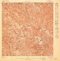
 1946 Adjuntas1946 Print · USGSAdjuntas and the surrounding central highlands are captured here in the mid-forties, showing a landscape defined by coffee and sugar estates. Researchers can trace the heritage of specific estates like Hacienda Jauca and Hacienda El Progreso or locate mountain landmarks such as Cerro El Gigante.2 unique versions available
 - 1947 Map of Adjuntas NO
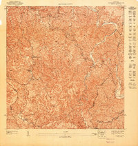
 1947 Adjuntas NO1947 Print · USGSThe central mountains of Puerto Rico come into focus during the late 1940s, showing a landscape of traditional agricultural estates. Genealogists and historians can trace the boundaries of family-named sites like Hacienda Tres Hermanas and the industrial hub at Central Pellejas.
 - 1947 Map of Adjuntas SO
 1947 Adjuntas SO1947 Print · USGSThe mountain town of Adjuntas and the high peaks of the Cordillera Central are shown here in the late 1940s. Genealogists and historians can trace old property lines along the Río Grande de Arecibo or locate landmarks like the Adjuntas Chimney and Lago Garzas.
 - 1947 Map of Adjuntas NE
 1947 Adjuntas NE1947 Print · USGSThe mountain interior of Utuado and Jayuya is captured in the late 1940s, highlighting a landscape shaped by coffee-growing history. Genealogists and historians can locate family landmarks like Hacienda Esperanza or the Iglesia de la Concepción Inmaculada.
 - 1947 Map of Adjuntas SE
 1947 Adjuntas SE1947 Print · USGSThe high peaks of the Cordillera Central come alive in this post-war survey of the Ponce and Adjuntas borderlands. Genealogists and historians can trace the legacy of old agricultural estates like Hacienda El Banco and the Iglesia de San Patricio.
 - 1952 Map of Adjuntas, 1953 Print
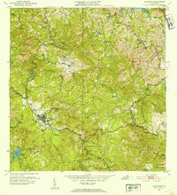 1952 Adjuntas1953 Print · USGSThe mountain municipality of Adjuntas is shown in the mid-fifties amidst its traditional agricultural barrios and coffee-growing haciendas. Genealogists and historians can locate specific family-named estates like Hacienda Artau and Hacienda El Progreso or old parish centers like Iglesia de San Patricio.2 unique versions available
 - 1960 Map of Adjuntas, 1962 Print
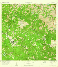 1960 Adjuntas1962 Print · USGSThe high mountain terrain of the Cordillera Central comes to life in the early 1960s, showing the intersection of coffee estate history and modern hydraulic engineering. Genealogists and historians can locate numerous family estates like Hacienda Tres Hermanas and community centers such as Iglesia de San Patricio.4 unique versions available
End of results
Showing maps 1-7 of 7
Frequently asked questions
- What are the different types of historical maps available for Vegas Abajo?
- What is the oldest map of Vegas Abajo?
- Where can I purchase historical maps of Vegas Abajo for my home or office?
- Where can I download high-res historical maps of Vegas Abajo?
- Are there historical topographic maps available for Vegas Abajo?
- Is there historical aerial imagery available for Vegas Abajo?
- Where are historical maps of Vegas Abajo sourced from?