1950s Maps of Aguas Buenas
Explore 9 historic maps of Aguas Buenas from the 1950s. These maps offer a rare glimpse into what life looked like during the 1950s — showing old roads, neighborhoods, homes, and landmarks that have changed or disappeared over time.
Whether you're researching your family's past, planning a metal detecting trip, or studying how Aguas Buenas's landscape evolved across the 1950s, these high-resolution maps are a powerful tool for exploring the history of this region.
- Focus on a specific era: All maps on this page are from the 1950s, giving you a focused view of this time period.
- See what’s changed: Compare century-old streets, trails, and buildings to today's modern landscape using overlays and satellite layers.
- Research with precision: Use these maps for genealogy, historical research, land use analysis, or educational projects.
- View, download, or print: Maps are fully viewable online in high resolution, and can be downloaded or printed for your own records.
Start exploring Aguas Buenas's history through authentic maps from the 1950s. This is your window into the past.
Aguas Buenas maps
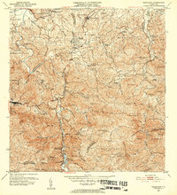
(9)- 1952 Map of Aguas Buenas, 1953 Print
 1952 Aguas Buenas1953 Print · USGSAguas Buenas and the surrounding central highlands of Puerto Rico are mapped here during a period of steady mid-century growth. Researchers can trace family sites near Barrio Bairoa or locate community centers like the Escuela Luis Santella and Leprocomio.2 unique versions available
 - 1952 Map of Naranjito, 1953 Print
 1952 Naranjito1953 Print · USGSNaranjito and the central highlands are captured here in the early fifties, showing a landscape of traditional agricultural colonias and developing barrios. Genealogists can locate specific family landmarks and local institutions like Iglesia de Minillas, Escuela Don Manolo, and the Represa de Comerio.2 unique versions available
 - 1952 Map of Caguas, 1953 Print
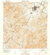 1952 Caguas1953 Print · USGSCaguas and the surrounding interior highlands are captured here in the early fifties, documenting the local sugar economy and mountain settlements. Researchers can locate family landmarks like Central Santa Juana, the Escuela Segunda Unidad de Turabo, and Capilla San Patricio.2 unique versions available
 - 1953 Map of Comerio
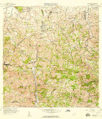
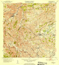 1953 Comerio1953 Print · USGSThe central mountains of Puerto Rico are mapped in the early fifties, showcasing the intricate river valleys and developing rural communities. Genealogists and local historians can trace the foundations of the regional school system and community centers like the Centro Comunal Nogueras, Escuela Superior de Comerio, and Cidra.2 unique versions available
 - 1955 Map of Aguas Buenas, 1956 Print
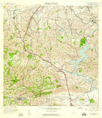
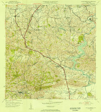 1955 Aguas Buenas1956 Print · USGSThe area surrounding Aguas Buenas is captured in the mid-fifties, showing the region before the extensive growth of the San Juan metro. Genealogists can trace family footprints through historic barrios like CAIMITO and CUPEL or locate old school sites like Escuela Segunda Unidad de Río Cañas.
 - 1957 Map of Aguas Buenas, 1959 Print
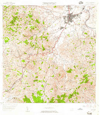
 1957 Aguas Buenas1959 Print · USGSAguas Buenas and the surrounding highlands are captured in the late fifties as the region's hydroelectric and communications infrastructure expanded. Researchers can trace family-named barrios and landmarks like Saint Just, Escuela Daniel Diaz, and the Leprosomio near the banks of Lago Loiza.
 - 1957 Map of Caguas, 1959 Print
 1957 Caguas1959 Print · USGSCaguas and its surrounding mountain barrios are shown here in the late fifties, just as the island's infrastructure was expanding. Genealogists and researchers can trace local landmarks like the Central Santa Juana, the Escuela Segunda Unidad de Turabo, and Capilla San Patricio.2 unique versions available
 - 1957 Map of Naranjito, 1959 Print
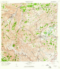
 1957 Naranjito1959 Print · USGSNaranjito and the central highlands of Puerto Rico appear in detail during the late 1950s, showing a landscape defined by sharp ridges and deep river valleys. Researchers can trace rural life through landmarks like Iglesia de la Monserrate and the Represa de San Juan reservoir.
 - 1957 Map of Comerio, 1960 Print
 1957 Comerio1960 Print · USGSThe central mountains of Puerto Rico are captured here in the late fifties, showing the relationship between steep-slope agriculture and growing urban centers. Researchers can trace family roots through numerous schools and barrios, from Escuela Segunda Unidad de Palomas to the hills of Sumidero.5 unique versions available
End of results
Showing maps 1-9 of 9
Frequently asked questions
- What are the different types of historical maps available for Aguas Buenas?
- What is the oldest map of Aguas Buenas?
- Where can I purchase historical maps of Aguas Buenas for my home or office?
- Where can I download high-res historical maps of Aguas Buenas?
- Are there historical topographic maps available for Aguas Buenas?
- Is there historical aerial imagery available for Aguas Buenas?
- Where are historical maps of Aguas Buenas sourced from?