Old Maps of Aguas Buenas for Genealogy
Trace your family roots with 35 historic maps of Aguas Buenas. These high-res maps reveal old neighborhoods, homesites, landmarks, and streets — helping you uncover where your ancestors lived and how the area evolved over time.
- Explore historic neighborhoods: Identify where your relatives may have lived in the 1800s or 1900s.
- Compare maps over time: Trace the changes in streets, buildings, and landmarks for multi-generational research.
- Perfect for genealogy & ancestry research: Used by family historians and researchers to map out lineage and migration.
These maps are an incredible resource for exploring your personal connection to Aguas Buenas's past.
Aguas Buenas maps
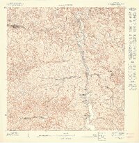
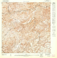
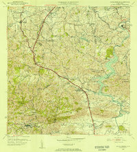
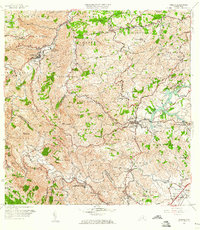
(35)- 1946 Map of Aguas Buenas
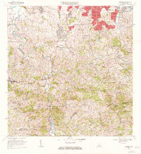
 1946 Aguas Buenas1946 Print · USGSAguas Buenas and the surrounding central highlands appear here in the mid-forties, showing the intricate network of mountain roads and rural settlements. Genealogists and historians can locate specific landmarks like the Leprocomio, Pueblo Seco, and several local Escuela Segunda Unidad schools.3 unique versions available
 - 1946 Map of Comerio
 1946 Comerio1946 Print · USGSThe Puerto Rican interior in the mid-forties shows a landscape of steep coffee-country peaks and river-valley towns. Genealogists can trace family footprints at Cidra, Centro Comunal Nogueras, and the Escuela Segunda Unidad de Toita.3 unique versions available
 - 1946 Map of Naranjito
 1946 Naranjito1946 Print · USGSNaranjito and the surrounding mountains of central Puerto Rico appear in the mid-1940s as a landscape of agricultural colonias and emerging utilities. Researchers can locate numerous rural chapels like the Iglesia Guadiana and trace the path of the Acueducto de San Juan through the hills.3 unique versions available
 - 1946 Map of Caguas
 1946 Caguas1946 Print · USGSCaguas and its surrounding sugar-producing valleys are captured here in the years following World War II. Local historians can trace the early industrial footprint of Central Santa Juana and find ancestral locations near Capilla San Patricio or the rural school at Escuela Segunda Unidad de Turabo.2 unique versions available
 - 1947 Map of Naranjito SO
 1947 Naranjito SO1947 Print · USGSNaranjito and the central highlands of Puerto Rico appear here in the 1940s, revealing a landscape shaped by the Rio de la Plata. Genealogists and local historians can trace parish sites like Iglesia Parroquial Corazon de Jesus and industrial sites like the Represa de Comerio.
 - 1947 Map of Naranjito SE
 1947 Naranjito SE1947 Print · USGSThe rural interior of Puerto Rico comes into focus during the late 1940s, showing a landscape defined by sharp ridges and winding river valleys. Genealogists and researchers can trace local congregations and infrastructure including the Iglesia Juan Ascencio and the Acueducto de San Juan.
 - 1947 Map of Caguas NO
 1947 Caguas NO1947 Print · USGSThe interior mountains of Puerto Rico are captured here in the late 1940s, showing the ridge-top roads and early settlements before modern expansion. Researchers can trace family-named landmarks and local religious life at the Capilla San Patricio or follow the path of the Rio Caguitas.
 - 1947 Map of Aguas Buenas SO
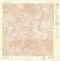
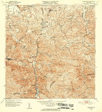
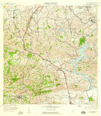
 1947 Aguas Buenas SO1947 Print · USGSAguas Buenas and the surrounding highlands are captured here in the late 1940s, showing the town and its rural outskirts before modern development. Genealogists and hikers can trace old routes near La Changa or follow the waters of Rio Bairoa and Rio Caguitas.
 - 1947 Map of Comerio NE, 1948 Print
 1947 Comerio NE1948 Print · USGSThe Puerto Rican interior highlands come into focus in the mid-1940s, showing a landscape defined by ridge-top trails and mountain agriculture. Local historians can trace the steep drainage of the Río La Plata and find early dwellings near Cerro Santa Bárbara and Quebrada Ceiba.
 - 1952 Map of Aguas Buenas, 1953 Print
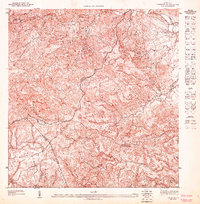
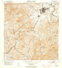
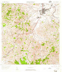
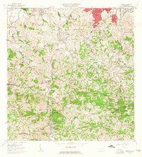
 1952 Aguas Buenas1953 Print · USGSAguas Buenas and the surrounding central highlands of Puerto Rico are mapped here during a period of steady mid-century growth. Researchers can trace family sites near Barrio Bairoa or locate community centers like the Escuela Luis Santella and Leprocomio.2 unique versions available
 - 1952 Map of Naranjito, 1953 Print
 1952 Naranjito1953 Print · USGSNaranjito and the central highlands are captured here in the early fifties, showing a landscape of traditional agricultural colonias and developing barrios. Genealogists can locate specific family landmarks and local institutions like Iglesia de Minillas, Escuela Don Manolo, and the Represa de Comerio.2 unique versions available
 - 1952 Map of Caguas, 1953 Print
 1952 Caguas1953 Print · USGSCaguas and the surrounding interior highlands are captured here in the early fifties, documenting the local sugar economy and mountain settlements. Researchers can locate family landmarks like Central Santa Juana, the Escuela Segunda Unidad de Turabo, and Capilla San Patricio.2 unique versions available
 - 1953 Map of Comerio
 1953 Comerio1953 Print · USGSThe central mountains of Puerto Rico are mapped in the early fifties, showcasing the intricate river valleys and developing rural communities. Genealogists and local historians can trace the foundations of the regional school system and community centers like the Centro Comunal Nogueras, Escuela Superior de Comerio, and Cidra.2 unique versions available
 - 1955 Map of Aguas Buenas, 1956 Print
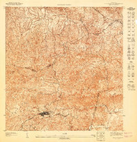
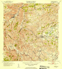
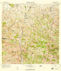
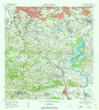
 1955 Aguas Buenas1956 Print · USGSThe area surrounding Aguas Buenas is captured in the mid-fifties, showing the region before the extensive growth of the San Juan metro. Genealogists can trace family footprints through historic barrios like CAIMITO and CUPEL or locate old school sites like Escuela Segunda Unidad de Río Cañas.
 - 1957 Map of Aguas Buenas, 1959 Print
 1957 Aguas Buenas1959 Print · USGSAguas Buenas and the surrounding highlands are captured in the late fifties as the region's hydroelectric and communications infrastructure expanded. Researchers can trace family-named barrios and landmarks like Saint Just, Escuela Daniel Diaz, and the Leprosomio near the banks of Lago Loiza.
 - 1957 Map of Caguas, 1959 Print
 1957 Caguas1959 Print · USGSCaguas and its surrounding mountain barrios are shown here in the late fifties, just as the island's infrastructure was expanding. Genealogists and researchers can trace local landmarks like the Central Santa Juana, the Escuela Segunda Unidad de Turabo, and Capilla San Patricio.2 unique versions available
 - 1957 Map of Naranjito, 1959 Print
 1957 Naranjito1959 Print · USGSNaranjito and the central highlands of Puerto Rico appear in detail during the late 1950s, showing a landscape defined by sharp ridges and deep river valleys. Researchers can trace rural life through landmarks like Iglesia de la Monserrate and the Represa de San Juan reservoir.
 - 1957 Map of Comerio, 1960 Print
 1957 Comerio1960 Print · USGSThe central mountains of Puerto Rico are captured here in the late fifties, showing the relationship between steep-slope agriculture and growing urban centers. Researchers can trace family roots through numerous schools and barrios, from Escuela Segunda Unidad de Palomas to the hills of Sumidero.5 unique versions available
 - 1963 Map of Naranjito, 1965 Print
 1963 Naranjito1965 Print · USGSNaranjito and the Puerto Rican interior are shown here during a period of rapid development in the 1960s. Researchers can trace rural school locations like Escuela Dajaos Sexto or explore the early power network at Planta Hidroeléctrica Comerío No 2.
 - 1964 Map of Caguas, 1966 Print
 1964 Caguas1966 Print · USGSMid-century Caguas is documented here during a period of rapid suburban growth and civic development. Genealogists and local historians can trace neighborhood foundations like El Condado and El Verde, or locate family landmarks including Escuela Gerardo Sellés Solá and Cementerio de Caguas.4 unique versions available
 - 1964 Map of Aguas Buenas, 1966 Print
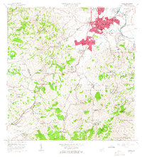
 1964 Aguas Buenas1966 Print · USGSIn the mid-1960s, the hills south of San Juan were transitioning from rural barrios to suburban communities. Researchers can trace family roots at Cementerio Municipal or locate historic schools such as Escuela Luis Santaella and Escuela Jose de Diego.
 - 1969 Map of Naranjito, 1972 Print
 1969 Naranjito1972 Print · USGSThe Naranjito and Bayamón regions undergo significant growth in the late sixties as residential developments meet industrial river infrastructure. Researchers can trace the development of Royal Town or locate the Planta Hidroeléctrica Comerio Num 1 and Escuela Miguel Cervantes Saavedra.3 unique versions available
 - 1969 Map of Aguas Buenas, 1972 Print
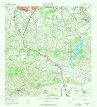
 1969 Aguas Buenas1972 Print · USGSThe foothills south of San Juan come alive in this late sixties survey as suburban growth reaches into the hills of Aguas Buenas. Genealogists and historians can trace the foundations of local life through the Leprocomio, the Antilles Military Academy, and dozens of rural schools like Escuela Jagueyes Abajo.4 unique versions available
 - 2013 Map of Comerio, 2013 Print
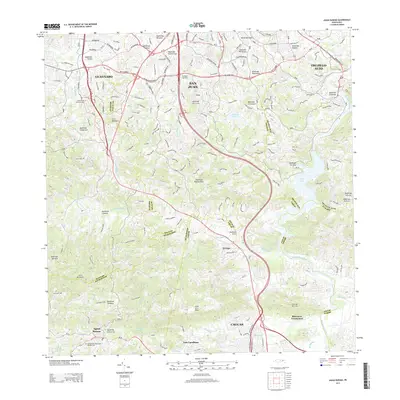
 2013 Comerio2013 Print · USGSCovers Aguas Buenas, including Cidra, Comerío, and other nearby areas
 - 2013 Map of Aguas Buenas, 2013 Print
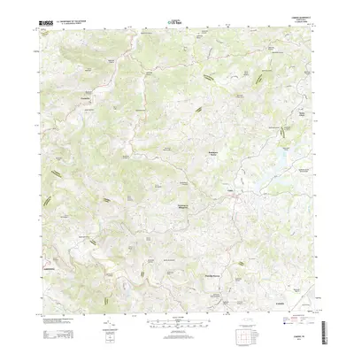
 2013 Aguas Buenas2013 Print · USGSCovers Aguas Buenas, including Guaynabo, Trujillo Alto, and other nearby areas
Showing maps 1-25 of 35
Frequently asked questions
- What are the different types of historical maps available for Aguas Buenas?
- What is the oldest map of Aguas Buenas?
- Where can I purchase historical maps of Aguas Buenas for my home or office?
- Where can I download high-res historical maps of Aguas Buenas?
- Are there historical topographic maps available for Aguas Buenas?
- Is there historical aerial imagery available for Aguas Buenas?
- Where are historical maps of Aguas Buenas sourced from?