1900s (20th Century) Maps of Carenero, Guánica
Explore 8 historic maps of Carenero from the 1900s (20th Century). These maps offer a rare glimpse into what life looked like during the 1900s — showing old roads, neighborhoods, homes, and landmarks that have changed or disappeared over time.
Whether you're researching your family's past, planning a metal detecting trip, or studying how Carenero's landscape evolved across the 1900s, these high-resolution maps are a powerful tool for exploring the history of this region.
- Focus on a specific era: All maps on this page are from the 1900s, giving you a focused view of this time period.
- See what’s changed: Compare century-old streets, trails, and buildings to today's modern landscape using overlays and satellite layers.
- Research with precision: Use these maps for genealogy, historical research, land use analysis, or educational projects.
- View, download, or print: Maps are fully viewable online in high resolution, and can be downloaded or printed for your own records.
Start exploring Carenero's history through authentic maps from the 1900s. This is your window into the past.
Carenero, Guánica maps
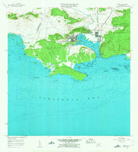
(8)- 1938 Map of Guanica
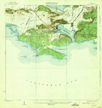 1938 Guanica1938 Print · USGSThe southern coast of Puerto Rico thrived as a sugar-producing powerhouse in the late 1930s, centered on the massive Central Guanica mill. Researchers can trace the industrial footprint of Ensenada, locate the historic Guanica LH, and find local schools like Escuela No 225.6 unique versions available
 - 1946 Map of Punta Verraco
 1946 Punta Verraco1946 Print · USGSThe southwestern coast of Puerto Rico is mapped in the mid-1940s, highlighting the intersection of the sugar industry and the sea. Researchers can trace the Porto Rico RR as it passes Central San Francisco and the hills of the Bosque Insular de Guánica y Guayanilla.3 unique versions available
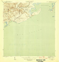
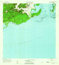
 - 1949 Map of Guanica NE
 1949 Guanica NE1949 Print · USGSThe industrial and maritime landscape of southwest Puerto Rico is captured here in the late 1940s. Genealogists and historians can trace the development of Ensenada, the operations at Central Guánica, and coastal landmarks like the Faro de Guánica.
 - 1952 Map of Punta Verraco, 1953 Print
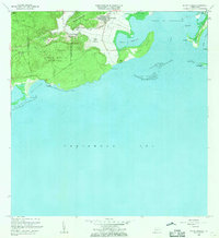
 1952 Punta Verraco1953 Print · USGSGuayanilla and Yauco meet the Caribbean Sea in the early fifties, showing a coast defined by sugar production and conservation lands. Genealogists and historians can locate early communities like Parcelas Barrio Indio and trace the influence of Central San Francisco.2 unique versions available
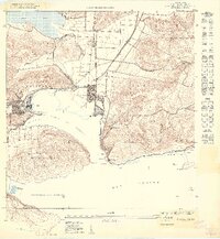
 - 1956 Map of Guanica, 1959 Print
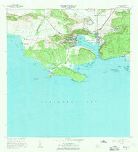
 1956 Guanica1959 Print · USGSThe southwestern coast of Puerto Rico is shown here in the mid-1950s, centered on the bustling sugar industry and salt works of the era. Researchers can trace the layout of Ensenada, the maritime importance of Faro de Guánica, and salt flats like Salinas Providencia.
 - 1958 Map of Punta Verraco, 1960 Print
 1958 Punta Verraco1960 Print · USGSCoastal Guayanilla and its sugar industry are captured in the late 1950s, showing the intersection of maritime trade and rural life. Researchers can locate Central San Francisco, the Escuela Arturo Lluberas, and reefs like Arrecife Guayanilla.2 unique versions available
 - 1966 Map of Punta Verraco, 1969 Print
 1966 Punta Verraco1969 Print · USGSCoastal Guayanilla in the mid-sixties reveals a landscape balancing the protected Bosque Estatal de Guanica with emerging petroleum industrial sites. Researchers can trace local life through the Central San Francisco sugar mill area, Barrio Indios, and the Escuela Arturo Lluberas.3 unique versions available
 - 1966 Map of Guanica, 1969 Print
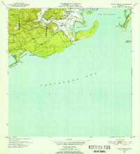
 1966 Guanica1969 Print · USGSCoastal Guánica in the mid-sixties reveals a landscape balancing the industrial output of Central Guánica with the protected reaches of the Bosque Estatal de Guánica. Researchers can trace the layout of Ensenada, locate the Faro de Guánica, and find family-named landmarks like Punta Montalva.3 unique versions available
End of results
Showing maps 1-8 of 8
Frequently asked questions
- What are the different types of historical maps available for Carenero?
- What is the oldest map of Carenero?
- Where can I purchase historical maps of Carenero for my home or office?
- Where can I download high-res historical maps of Carenero?
- Are there historical topographic maps available for Carenero?
- Is there historical aerial imagery available for Carenero?
- Where are historical maps of Carenero sourced from?