1950s Maps of Palmas, Guayama
Explore 4 historic maps of Palmas from the 1950s. These maps offer a rare glimpse into what life looked like during the 1950s — showing old roads, neighborhoods, homes, and landmarks that have changed or disappeared over time.
Whether you're researching your family's past, planning a metal detecting trip, or studying how Palmas's landscape evolved across the 1950s, these high-resolution maps are a powerful tool for exploring the history of this region.
- Focus on a specific era: All maps on this page are from the 1950s, giving you a focused view of this time period.
- See what’s changed: Compare century-old streets, trails, and buildings to today's modern landscape using overlays and satellite layers.
- Research with precision: Use these maps for genealogy, historical research, land use analysis, or educational projects.
- View, download, or print: Maps are fully viewable online in high resolution, and can be downloaded or printed for your own records.
Start exploring Palmas's history through authentic maps from the 1950s. This is your window into the past.
Palmas, Guayama maps
(4)- 1952 Map of Guayama, 1953 Print
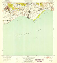 1952 Guayama1953 Print · USGSCoastal Puerto Rico in the early fifties reveals a landscape shaped by sugar production and maritime trade. Local researchers can find named estates and industrial sites like Central Lafayette, Colonia Algarrobo, and the Faro Pta Figuras lighthouse.2 unique versions available
 - 1952 Map of Patillas, 1953 Print
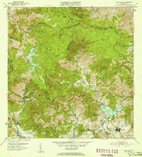 1952 Patillas1953 Print · USGSSoutheastern Puerto Rico is depicted here during the mid-twentieth century, showcasing the vital water and power systems of the Sierra de Cayey. Researchers can locate agricultural landmarks like Hacienda Felicita and public works including the Carite No. 1 hydroelectric plant.2 unique versions available
 - 1952 Map of Central Aguirre, 1953 Print
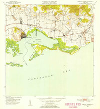 1952 Central Aguirre1953 Print · USGSThe sugar-producing coastal plains of southern Puerto Rico are captured here in the early fifties, showcasing the vital infrastructure of the era. Genealogists and historians can trace the plantation economy through estate labels like Hacienda Mercedes, the port at Puerto Jobos, and the worker communities of Central Aguirre.2 unique versions available
 - 1953 Map of Cayey
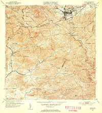 1953 Cayey1953 Print · USGSThe mountain town of Cayey and its surrounding barrios are documented here in the early 1950s during a period of transition and growth. Researchers can trace land ownership and community centers through labels for Hacienda Clavell, Poblado Carmen, and the Iglesia Sagrado Corazon.2 unique versions available
End of results
Showing maps 1-4 of 4
Frequently asked questions
- What are the different types of historical maps available for Palmas?
- What is the oldest map of Palmas?
- Where can I purchase historical maps of Palmas for my home or office?
- Where can I download high-res historical maps of Palmas?
- Are there historical topographic maps available for Palmas?
- Is there historical aerial imagery available for Palmas?
- Where are historical maps of Palmas sourced from?