1970s Maps of Palmas, Guayama
Explore 4 historic maps of Palmas from the 1970s. These maps offer a rare glimpse into what life looked like during the 1970s — showing old roads, neighborhoods, homes, and landmarks that have changed or disappeared over time.
Whether you're researching your family's past, planning a metal detecting trip, or studying how Palmas's landscape evolved across the 1970s, these high-resolution maps are a powerful tool for exploring the history of this region.
- Focus on a specific era: All maps on this page are from the 1970s, giving you a focused view of this time period.
- See what’s changed: Compare century-old streets, trails, and buildings to today's modern landscape using overlays and satellite layers.
- Research with precision: Use these maps for genealogy, historical research, land use analysis, or educational projects.
- View, download, or print: Maps are fully viewable online in high resolution, and can be downloaded or printed for your own records.
Start exploring Palmas's history through authentic maps from the 1970s. This is your window into the past.
Palmas, Guayama maps
(4)- 1970 Map of Central Aguirre, 1972 Print
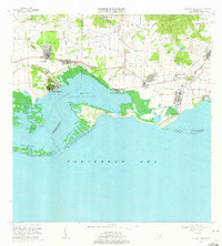 1970 Central Aguirre1972 Print · USGSThe southern coast of Puerto Rico comes alive in this 1970s survey of the sugar-producing heartland. Genealogists and historians can trace company town life at Central Aguirre and Coquí, or explore the maritime landscape of Bahía de Jobos and Las Mareas.3 unique versions available
 - 1970 Map of Guayama, 1972 Print
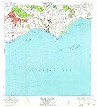 1970 Guayama1972 Print · USGSThe southern coast of Puerto Rico thrived as a sugar and maritime hub in the early seventies. Genealogists and historians can trace the irrigation canals and residential expansion of Guayama or locate old industrial sites like Central Machete and Central Lafayette.4 unique versions available
 - 1972 Map of Patillas, 1974 Print
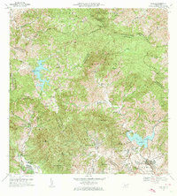 1972 Patillas1974 Print · USGSSoutheast Puerto Rico in the early seventies shows a landscape defined by the Sierra de Cayey and its vital reservoirs. Genealogists and local historians can trace family locations through rural barrios like Yaurel, identify local schools such as Escuela Leonor Ramos, and locate landmarks like Lago Patillas.4 unique versions available
 - 1972 Map of Cayey, 1974 Print
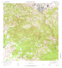 1972 Cayey1974 Print · USGSThe mountain town of Cayey and the surrounding Cordillera Central peaks are captured here in the early seventies. Genealogists and historians can trace family estates like Hacienda Clavell and Hacienda Julia, or locate civic landmarks like the Casilla del Gobernador.2 unique versions available
End of results
Showing maps 1-4 of 4
Frequently asked questions
- What are the different types of historical maps available for Palmas?
- What is the oldest map of Palmas?
- Where can I purchase historical maps of Palmas for my home or office?
- Where can I download high-res historical maps of Palmas?
- Are there historical topographic maps available for Palmas?
- Is there historical aerial imagery available for Palmas?
- Where are historical maps of Palmas sourced from?