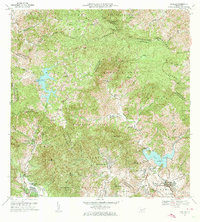
1972 Map of Patillas
USGS Topo · Published 1974About this map
The Sierra de Cayey dominates this interior landscape of southeastern Puerto Rico, where the ridge lines define the boundaries of several municipalities including Cayey and Patillas. The geography is anchored by two significant water bodies at vastly different elevations: the highland reservoir of Lago Carite in the northwest and Lago Patillas in the southeast. Winding through these peaks, the Carretera Panoramica provides transit across the divide, connecting isolated barrios such as Guayabota and Quebrada Arriba.
Find a feature on this map
74 named features on this map. Tap any name to fly to it.
Don’t see what you’re looking for? This feature index may not catch every label — zoom into the map to look around manually.
Map Details
Editions of this 1972 Patillas Map
4 editions found
Other maps of this area

1945 · Punta Tuna
USGS Topo · 1:30,000

1945 · Central Aguirre
USGS Topo · 1:30,000

1946 · Patillas
USGS Topo · 1:30,000

1946 · Cayey
USGS Topo · 1:30,000

1946 · Comerio
USGS Topo · 1:30,000

1946 · Juncos
USGS Topo · 1:30,000

1946 · Yabucoa
USGS Topo · 1:30,000

1946 · Guayama
USGS Topo · 1:30,000

1946 · Caguas
USGS Topo · 1:30,000

1947 · Yabucoa SO
USGS Topo · 1:10,000
Featured Places
- Patillas
- Sector Los Meléndez, Cayey
- Villa Kike, San Lorenzo
- Villa Real, Patillas
- Sector Conejo Blanco, Patillas